
Press release:
The Metropolitan Washington Council of Governments (COG) has forecast a Code Orange air day for tomorrow, August 27 in part of the metropolitan Washington region, including DC and Northern Virginia as well as Suburban DC in Maryland (Prince George’s County and Lower Montgomery County). Code Orange levels mean the air is unhealthy for sensitive groups.
Air quality levels can vary across the region. Residents can check current air quality conditions near them on COG’s website or the Clean Air Partners website. Conditions could also be favorable for another Code Orange forecast on Wednesday. Forecasts are updated around 4 P.M. each day on COG’s website.
On unhealthy air days, COG advises area residents to take the following actions:
Avoid lawn mowing or use an electric mower.
Use gas or electric grills instead of charcoal.
Fill your vehicles’ gas tank after sunset.
Take transit, carpool, or work from home.
Turn off lights and electronics when not in use and follow tips from your electric utility about how to use less electricity to cool your home.COG, in partnership with the District Department of Energy & Environment and Virginia Department of Environmental Quality, provides daily air quality forecasts for the Northern Virginia/District of Columbia region. Daily air quality forecasts for Suburban DC (Prince George’s County and Lower Montgomery County), Maryland Piedmont (Frederick County and Upper Montgomery County), and/or Southern Maryland (Charles and Calvert Counties) are provided by Maryland Department of the Environment.
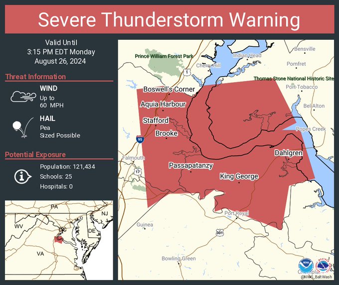
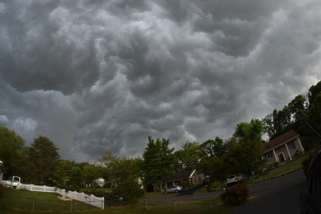
The National Weather Service has issued a severe thunderstorm warning for Stafford County, including Aquia Harbour and King George, effective until 3:15 p.m. today. This warning comes as a series of storm clusters, currently over Johnstown, PA, and extending across Lake Erie, are expected to intensify as they approach the region.
As of 9:45 a.m., satellite and radar imagery showed several clusters of showers accompanied by occasional lightning moving southeastward.
Meteorologists are monitoring these storm clusters to determine whether they will maintain their strength and become severe as they encounter increasing instability during the day. The potential for severe weather arises as these systems interact with a corridor of weak convergence, noted from western Maryland southeastward towards Fredericksburg. This area is expected to strengthen with additional waves of activity pivoting around an upper-level low to the north.
Despite some limiting factors such as poor mid-level lapse rates and modest atmospheric forcing, scattered convection with a few strong to severe thunderstorms is possible this afternoon and early evening. The primary concern with these storms is the risk of localized damaging wind gusts, with a conditional low-end threat for severe hail if supercell structures develop.
The National Weather Service also notes that following today’s storms, temperatures will likely dip into the mid-60s to lower 70s overnight, with potential for development, particularly in areas that receive rainfall.
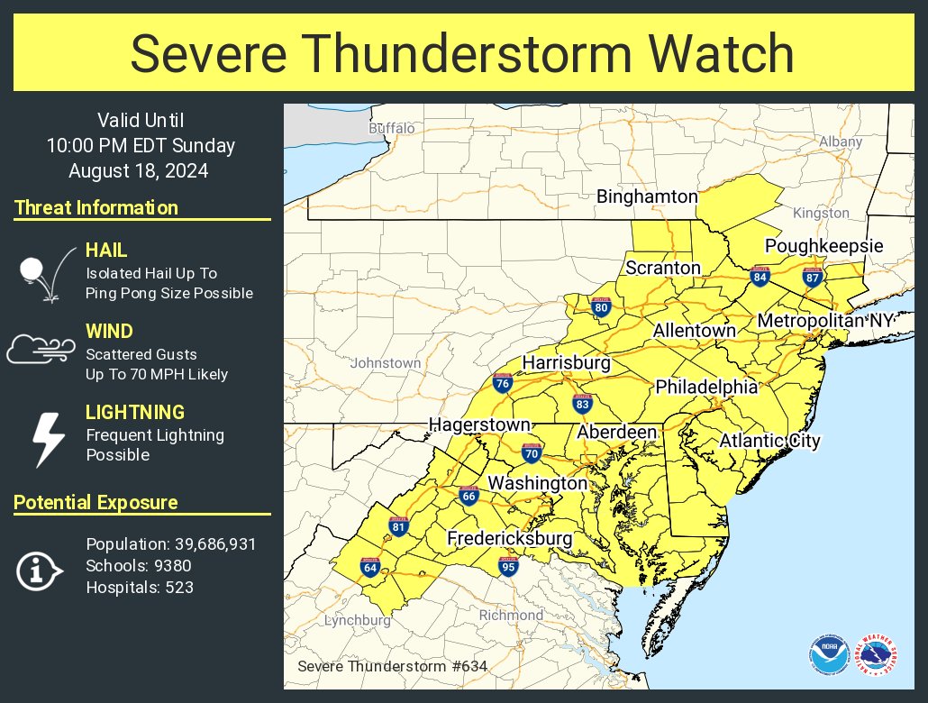
The National Weather Service has issued a severe thunderstorm watch for the region until 10 p.m. on Sunday, August 18. A slow-moving cold front will bring showers and thunderstorms throughout the day. The highest chances of precipitation are expected this afternoon and evening as the front moves across the area.
We can expect the storms to produce damaging wind gusts and isolated instances of flooding. The potential for large hail or an isolated tornado also exists due to increasing instability in the atmosphere, according to the National Weather Service.
A Flood Watch has also been issued from 2 to 8 p.m. this afternoon through this evening for parts of Northeast Maryland and the Washington, D.C. area. Some storms may produce rainfall rates of one to two inches per hour, leading to isolated instances of urban flooding in vulnerable areas.
Temperatures are expected to range from the 70s to 80s, with overnight lows dropping into the 60s to low 70s. After the cold front passes, dry conditions and cooler temperatures will return next week as high pressure builds in from the northwest.
The National Weather Service has issued a Tornado Watch in effect from 6:19 a.m. to 2 p.m. on Friday, Aug. 9. The watch follows multiple reports of a tornado touching down in Caroline County yesterday evening.
The storm is predicted to bring significant rainfall to the area, with risks of flooding possible. The Rappahannock River last flooded downtown Fredericksburg on Jan. 10, 2024. It crested at 19.1 feet at 5:30pm, impacting Old Mill Park and encroaching trails along Fall Hill Avenue. Fredericksburg has already closed Old Mill Park in anticipation of Tropical Storm Debby.
Fredericksburg: Tropical Storm Debby’s main system is moving north into Virginia from North Carolina. The current forecast track is that the main part of the storm will remain to our west, generally travelling from south to north along the Interstate 81 corridor. That said, the Fredericksburg area will see significant rainfall, with rain bands that could be heavy at times beginning mid-afternoon today, Thursday, through the overnight hours, and decreasing sometime around mid-afternoon tomorrow. This system has also spawned thunderstorm and tornado activity, so please stay alert and continue to monitor conditions in case those develop.
Here are some updates from the City of Fredericksburg, along with some tips and updates as the storm moves through Virginia:
- Old Mill Park, Alum Spring Park and the Dog Park are now closed due to wet conditions. Park staff is monitoring water levels and other parks could be closed due to high water levels or adverse conditions.
- Heavy rain to the west of Fredericksburg may lead to flood conditions for the Rappahannock River, even after the storm passes. Continue to monitor FredericksburgAlert.com or the City’s website at www.fredericksburgva.gov for the latest river conditions.
- City Staff from all departments have been preparing for Tropical Storm Debby and our Public Safety and Public Works teams are ready to respond.
- FXBGO! Transit operations are still on schedule at this time.
- City Government offices are open and will remain open as regularly scheduled.
To mitigate the effects of drought, Fauquier County residents, businesses, and government agencies should adopt various water conservation practices, including efficient use of household appliances and mindful irrigation techniques.
Press release:
Potential Means of Water Conservation:
No matter what drought level Fauquier County is in, residents, businesses, communities and government agencies can, and should, critically evaluate and explore more efficient water conservation practices. The following list of water conservation practices is not intended to be a complete or exhaustive list, but rather to provide some examples of what can be done to conserve water:
• Use dishwaters only when they are full.
• Wash only full loads of laundry (adjust water level if possible).
• Turn off faucets while brushing teeth, shaving, etc. (saves about five gallons per day).
• Reduce water used per toilet flush by installing toilet tank displacement inserts. A plastic jug may be used as an alternative. [Note: do not use bricks.
They disintegrate when soaked and the resulting grit hinders closing of the flap value, causing leakage and subsequent water loss].• Keep a bottle of water in the refrigerator, so as to limit the running of tap water to get cold water.
• If you have a water meter, monitor it to evaluate how much water you use and the timing of this use, so as to better inform you of how you may create additional water savings.
• Take shorter showers and baths (saves about 25 gallons per shower/bath).
• Do not use a garbage disposal.
• Do not use water to wash off driveways or sidewalks.
• Water before 10:00 a.m. to reduce evaporation during the hottest part of the day. Watering in the morning is better than the evening, because the dampness and coolness of the evening may promote fungal growth.
• When watering plants, use drip irrigation that directs water to the root system. If you do not have drip irrigation capabilities, then closely monitor your watering to ensure that the water is turned off when sufficient water has been delivered. Avoid run-off.
• When watering plants, water infrequently but thoroughly, because water penetrating deeper in the soil will be retained longer and it will encourage plants to grow deeper roots. Conversely, water from
frequent light waterings often is lost due to evaporation, and it encourages plants to grow in the shallow soil zones that dry out quickly causing greater plant stress and the need for additional waterings.• Water lawns only when necessary [note: grass that springs back when stepped on does not need water].
• Install automatic shut-off nozzles on outdoor water hoses.
• Aerate lawns by punching small holes approximately six inches apart. This will encourage water to soak into the soil rather than run off the surface.
• Position manually-placed sprinklers so that they do not water pavement, gravel, buildings or other non-plant surfaces.
• Know how to turn off an automatic irrigation system in case of rain.
• Weed gardens so that more desirable plants do not have to compete for limited moisture.
• Mulch garden beds to reduce evaporative water loss and weed growth, and cool the soil, which in turn creates less water-stress to plants.
• During dry periods postpone new plantings, since new plantings often require a higher quantity of irrigation.
• Use trash cans to dispose of used tissues rather than flushing them down the toilet.
• Avoid mowing grass at a very short height, since more water evaporates from short grass than taller grass.
• Do not allow children to play water games.
• Encourage the use of rain barrels and other means to capture and re-use water.
• Turn off ornamental water fountains.
• Avoid irrigation of athletic fields.
• Discourage the filling or topping off outdoor swimming pools.
• Avoid washing car, boats, and other personal or recreational equipment.
• Serve water to restaurant patrons only upon request.
For citizens on a public water system through FCWSA or a Town water system, please refer to their specific guidance at:
? https://www.fcwsa.org
? https://www.warrentonva.gov
? https://www.remington-va.gov
The County will continue to monitor DEQ guidance and warning advisories over the coming weeks. The County will issue updated guidance and restrictions, as advised by DEQ and in consultation with FCWSA and our Towns. The following provide specific guidance and protocols for Statewide and County level drought planning.For DEQ: https://www.deq.virginia.gov/our-programs/water/water-quantity/drought For Fauquier County’s Comprehensive Drought Management and Emergency Preparedness Plan: https://www.fauquiercounty.gov/home/showpublisheddocument/12951/638139461778070000.
(ENDS)
Severe Thunderstorm Warning including Spotsylvania Courthouse VA and Spotsylvania VA until 6:45 PM EDT pic.twitter.com/9oNRSK5roo
— NWS Baltimore-Washington (@NWS_BaltWash) June 30, 2024
In addition to the warning for Spotsylvania County, a severe thunderstorm watch is in place for the surrounding regions until 11 p.m. tonight. Residents should remain vigilant and prepared for sudden weather changes.
Earlier today, mid- and high-level cloud cover delayed heating, postponing the initiation of convective activity. However, clouds gradually develop, indicating increasing instability, particularly in the east.
Additional showers and thunderstorms may form along a surface cold front across central and southwestern Pennsylvania. Storms could organize and intensify, posing a predominant threat of damaging winds. According to the National Weather Service, isolated instances of hail are possible, and there is a brief potential for tornadoes near the Chesapeake Bay.
This evening, the greatest coverage of storms is expected across southern Maryland. With precipitable water values near or above two inches, heavy rainfall rates are possible with any storm. However, the flood threat remains limited due to the dry ground conditions.
There is uncertainty regarding the occurrence of two rounds of storms in any one location, which may depend on the extent of initial storm activity and the atmosphere’s recovery before the cold front’s arrival this evening. Storms are expected to clear southern Maryland around midnight.
Temperature and Heat Index
Despite the delayed heating, temperatures are climbing into the 90s, with localized heat index values nearing or exceeding 105 degrees along the I-95 corridor, albeit only for a short duration.
Post-Storm Conditions
Gusty northerly winds behind the cold front will bring much cooler and drier air late tonight. Overnight lows will drop into the mid-50s to mid-60s, with temperatures possibly reaching the 40s in higher elevations.
Residents are advised to stay updated with the latest weather information and take necessary precautions to ensure safety during severe weather conditions.