
What You Need to Know:
Snow Emergency Routes: When a Snow Emergency is declared, parking will be prohibited on designated snow emergency routes. These streets are prioritized for plowing to ensure safe travel for residents and emergency vehicles. Check the city’s snow map at manassasva.gov/snowmap to see which roads are included and what will be plowed first.
Limit On-Street Parking: Even before an official Snow Emergency is declared, residents are encouraged to limit on-street parking to facilitate plowing and snow removal efforts.
Reporting Issues: If you encounter snow-related concerns, call the Snowline at 703-257-8353 to report issues.
City’s Snow Removal Efforts
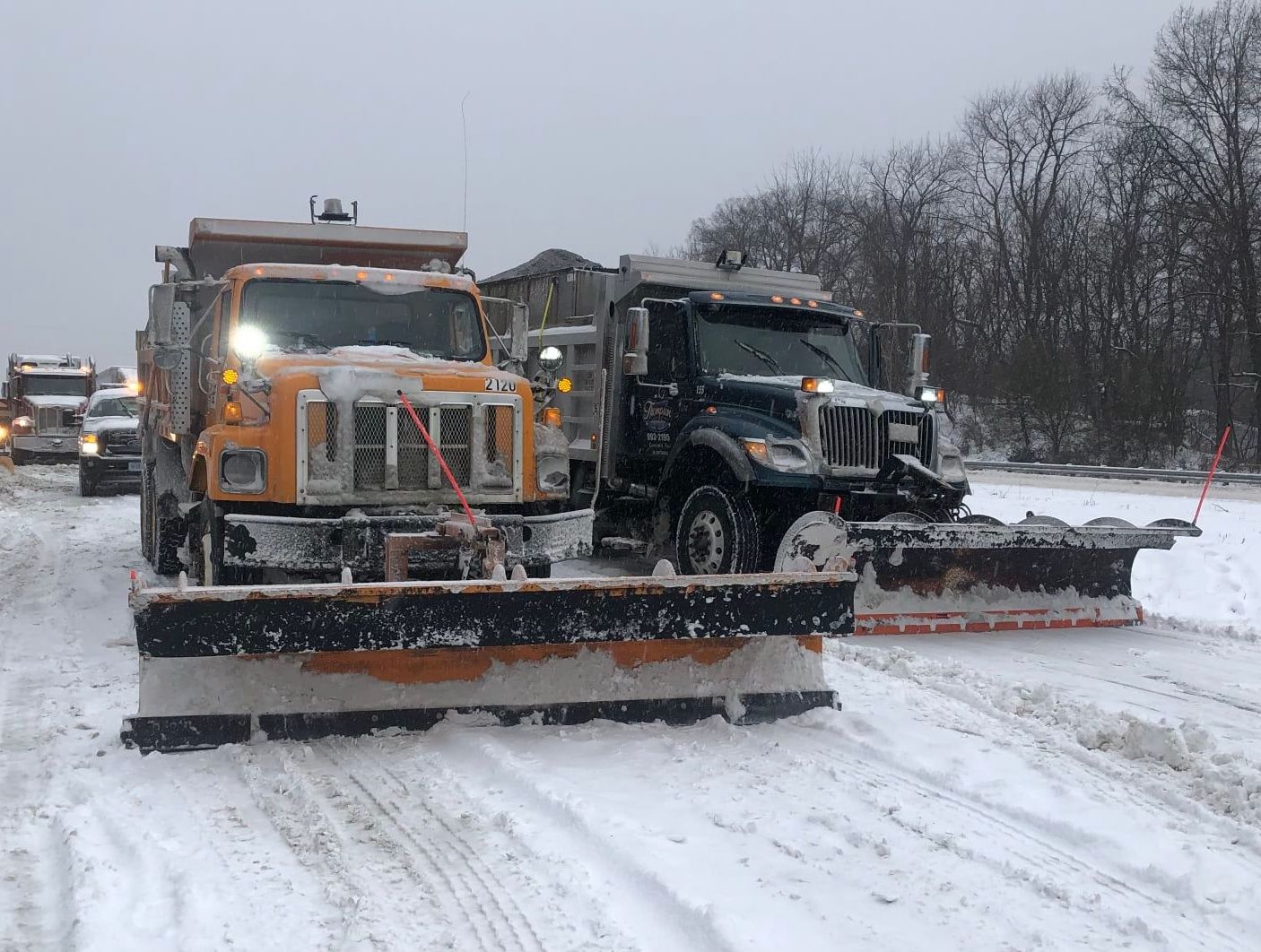
The City of Manassas Street Department is responsible for clearing over 254 lane miles of roadway. In addition to roads, the department ensures that public spaces are treated and cleared, including:
- City schools
- Commuter rail and public parking lots
- City Hall, Animal Shelter, Boys and Girls Club, Public Works Facility, Fire, Rescue, and Police facilities
City officials are asking for cooperation from residents to make snow removal safe and efficient. For more details on the city’s snow removal process, visit manassasva.gov/snow.
Here’s more information about when to expect the storm to begin, as well as early forecasted snow totals.
Please send us photos of the snow—text to 571-989-1695 or email them to us.

Residents across the area are preparing for a major winter storm that is expected to bring significant snowfall beginning this evening and continuing into Tuesday. The National Weather Service has upgraded Winter Storm Watches to Warnings, signaling potential snow accumulations of 5 inches or more in many areas.
Current Conditions
The day began with sunny skies, but clouds are expected to increase throughout the afternoon as a powerful winter storm system approaches Oklahoma. High temperatures today will remain in the 30s, with colder conditions in higher elevations. Gusty west winds persist but are less intense than previous days.
Storm Timeline
This evening, snow may begin in the southwestern parts of the region after 3 p.m., though most areas will see precipitation start closer to 6 p.m. or later. Overnight, snowfall rates could reach 1 to 2 inches per hour during the storm’s peak intensity late tonight into Monday morning.
Snow will continue through Monday morning before becoming lighter in the afternoon as the storm weakens. A secondary burst of moderate to heavy snow is possible Monday night as the system’s upper-level low moves overhead. By Tuesday, lighter upslope snow showers may linger, with widespread refreezing expected overnight as temperatures drop into the teens.
Snowfall Predictions
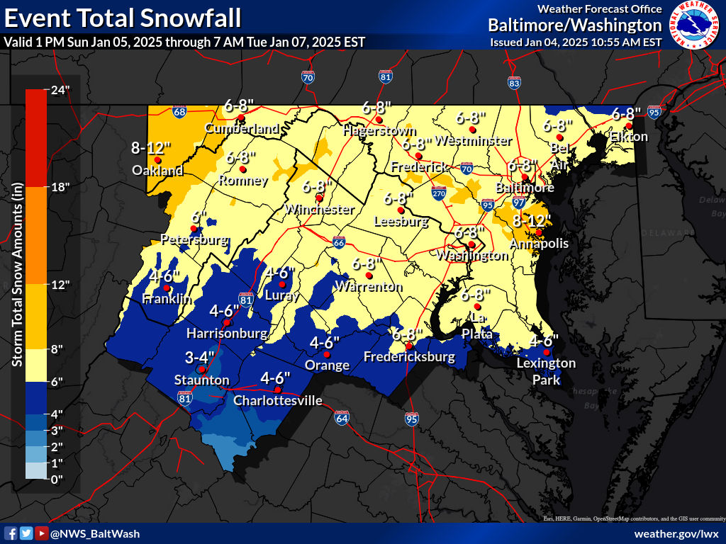
The storm’s exact impact depends on several factors, including where the heaviest snow bands form and how far north warmer air intrudes. Northern Maryland could see lighter snowfall or potentially some of the highest totals if the northern snow bands intensify. Areas near the I-66 corridor may experience some mixing of sleet or freezing rain, reducing snow totals. Central Virginia and southern Maryland are expected to see the heaviest snowfall, potentially nearing a foot in some locations.
Refreezing and Road Conditions
With temperatures dipping into the teens Tuesday night, widespread refreezing of untreated surfaces is likely, creating hazardous travel conditions. Residents are urged to stay off the roads during the storm and prepare for potential disruptions.
We’ll be posting more storm-related news in the coming hours, so stay tuned.
The National Weather Service has issued a winter storm warning for portions of Washington, D.C., central Maryland, and northern Virginia. The warning is effective from 10 p.m. Sunday, January 5, through 1 a.m. Tuesday, January 7.
The National Weather Service said we should expect:
- Snow and sleet accumulation between 5 and 9 inches, with isolated areas receiving up to 12 inches in heavy snow bands.
- Light ice accumulation is possible near Interstate 66.
- Snow will begin late Sunday, intensify overnight, and may mix with sleet and freezing rain on Monday morning. A lull in precipitation is expected during the afternoon.
Roads, bridges, and overpasses will likely become slick and hazardous, making travel difficult. Monday morning and evening commutes are expected to be affected.
Travelers are urged to postpone non-essential travel. If travel is unavoidable, prepare a winter storm kit, including tire chains, flashlights, food, water, blankets, and other emergency supplies. Stay informed by checking road conditions and monitoring weather updates.
This potent winter storm stems from a complex weather system involving a closed upper low and a surface low tracking eastward. The storm will bring an initial burst of snow Sunday night, with snowfall rates of 1–2 inches per hour in the heaviest bands. On Monday, warmer air may introduce a mix of sleet and freezing rain, particularly south of I-66 and U.S. Route 50.
Uncertainty remains regarding the exact path of the system, with models presenting differing scenarios. Regardless, significant snow and mixed precipitation impacts are expected for most of the region.
Preparedness Tips:
- Postpone non-essential travel.
- Ensure your vehicle is winter-ready and stocked with emergency supplies.
- Stay informed by monitoring updates from the National Weather Service and local authorities.
This storm is shaping up to be a significant event. Stay tuned to Potomac Local News for updates as the situation evolves.
Residents across Fredericksburg, Manassas, and Woodbridge should brace for what could be the most significant winter storm in years, with snow accumulations of 4 to 12 inches forecasted. The storm is set to begin Sunday afternoon, bringing snow, sleet, and freezing rain through Monday and potentially into early Tuesday.
Governor Glenn Youngkin has declared a state of emergency for Virginia, mobilizing state resources to prepare for hazardous conditions. The National Weather Service reports that the storm’s impact will depend on its track, with a northern trajectory bringing more ice and a southern track resulting in heavier snow across the area.
The Virginia Department of Transportation (VDOT) has activated its highest level of preparedness. “We’re mobilizing more than 900 pieces of equipment and have pre-treated major roadways, including Interstate 95, with brine to prevent ice from bonding to surfaces,” said Kelly Hannon of VDOT’s Fredericksburg District. Crews are also staging towing equipment along major routes to quickly address incidents.
Travel Warnings and Road Preparations
VDOT urges residents to complete all essential travel by Sunday and avoid driving during the storm. “Staying off the roads not only ensures your safety but allows our crews to clear snow and ice effectively,” Hannon emphasized. The storm is expected to bring snow at rates of up to an inch per hour, with periods of sleet and freezing rain complicating road conditions. Frigid temperatures following the storm could prolong icy conditions, hindering recovery efforts.
Lessons from the Past
Memories of the January 2022 snowstorm that stranded motorists on Interstate 95 loom large for hours. Hannon stressed the importance of staying home during hazardous weather, as treacherous conditions can halt even the most prepared response teams.
VDOT plans to prioritize interstates and primary roads but acknowledges that secondary streets may take longer to clear. Residents can track road-clearing progress through VDOT’s online resources.
As the storm approaches, Potomac Local News will provide updates on closures, travel conditions, and recovery efforts. Residents are encouraged to subscribe to our email newsletter or follow us online for the latest information.
Officials urge everyone to heed warnings and prepare for several days of challenging weather.

Get ready for a sharp drop in temperatures and gusty winds as a strong cold front moves through the region tonight into Thursday morning, according to the National Weather Service.
Forecast Overview
Thursday Morning: A mix of rain and snow showers may persist until 10 a.m., transitioning to snow in some areas briefly before tapering off. Temperatures will fall to around 33°F by late afternoon. Strong west winds at 16-20 mph could gust as high as 46 mph—precipitation chance: 40%.
Thursday Night: Skies will clear, but it will remain cold with lows around 29°F. Winds will continue from the west at 14 mph, with gusts up to 23 mph.
What to Expect
The powerful cold front will bring:
- Windy Conditions: Gusts could reach up to 46 mph, with the potential to cause isolated power outages and downed tree limbs.
- Chilly Temperatures: Wind chills will make temperatures feel much colder, especially on Thursday night when it could feel like the teens or single digits in some areas.
- Precipitation: A mix of rain and snow may lead to slick spots during the morning commute, especially in higher elevations and areas northwest of the immediate area.
Potential Impacts
- Power Outages: High winds may result in minor power disruptions, so residents should charge devices and prepare for outages.
- Travel Safety: Due to dangerous conditions, including whiteouts and reduced visibility, drivers in the mountains or other high elevations are advised to avoid non-essential travel.
The cold snap is expected to continue through Friday, but high pressure moving in will bring a gradual warming trend over the weekend. By early next week, another weather system could increase the chance of rain in the area.
Residents are encouraged to stay updated on the latest weather forecasts and advisories. Those in higher-risk areas should prepare for rapidly changing conditions and consider limiting travel during peak wind and snow times.
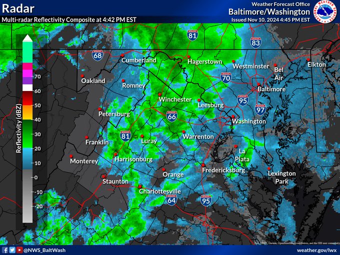
According to the U.S. Drought Monitor, residents in Northern Virginia and surrounding areas saw their first raindrops in almost 40 days this Sunday. The raindrops offered much-needed relief from a prolonged dry spell that has placed the region under moderate to severe drought conditions.
The National Weather Service has classified parts of Prince William County, Stafford County, Fredericksburg, Manassas, Manassas Park, and Spotsylvania County as experiencing a D1 Moderate Drought. Meanwhile, Fairfax County, King George County, and the Northern Neck Peninsula are experiencing a D2 severe drought.
Rainfall Totals and Forecast
According to the National Weather Service’s recent forecast, scattered showers are expected to bring between a tenth and a quarter inch of rain across much of the region tonight, with the heaviest rainfall anticipated in the northwest. The rain is associated with a warm front moving across the area and a cold front trailing behind. Temperatures will remain mild, hovering in the 50s and upper 40s overnight.
The rain will continue into Monday, providing an additional tenth to a quarter inch of precipitation in some areas, with localized areas in the northwest receiving as much as half an inch. This short-lived respite is expected to clear by Monday afternoon, making way for higher temperatures that may reach the mid-70s.
Drought Conditions and Fire Weather Concerns
The drought has dried up soil moisture levels, increasing the risk of regional fire hazards. The National Weather Service cautioned that the fire weather threat may need to be revisited, with little rain and dry conditions expected to persist through Tuesday.
The rain showers may not fully alleviate the drought’s effects. Northern Virginia typically expects around 3-4 inches of rainfall per month in the autumn, making it difficult to offset a 40-day rain deficit with a single system. However, the showers bring much-needed moisture to dry soils, especially in the more severely affected areas.
A secondary cold front will pass through the area on Tuesday, bringing seasonably cool temperatures and dry conditions. Northern Virginians can expect breezy weather on Tuesday, with cooler temperatures as high pressure builds in for mid-week. While this system brings short-term relief, additional rainfall is needed to fully replenish the region’s water levels and ease drought conditions.
Forecasters anticipate another front crossing the area between Thursday and Friday, potentially bringing more rain to further aid the drought-stricken region.
Update 11:45 a.m. — From Stafford fire and rescue’s Facebook page:
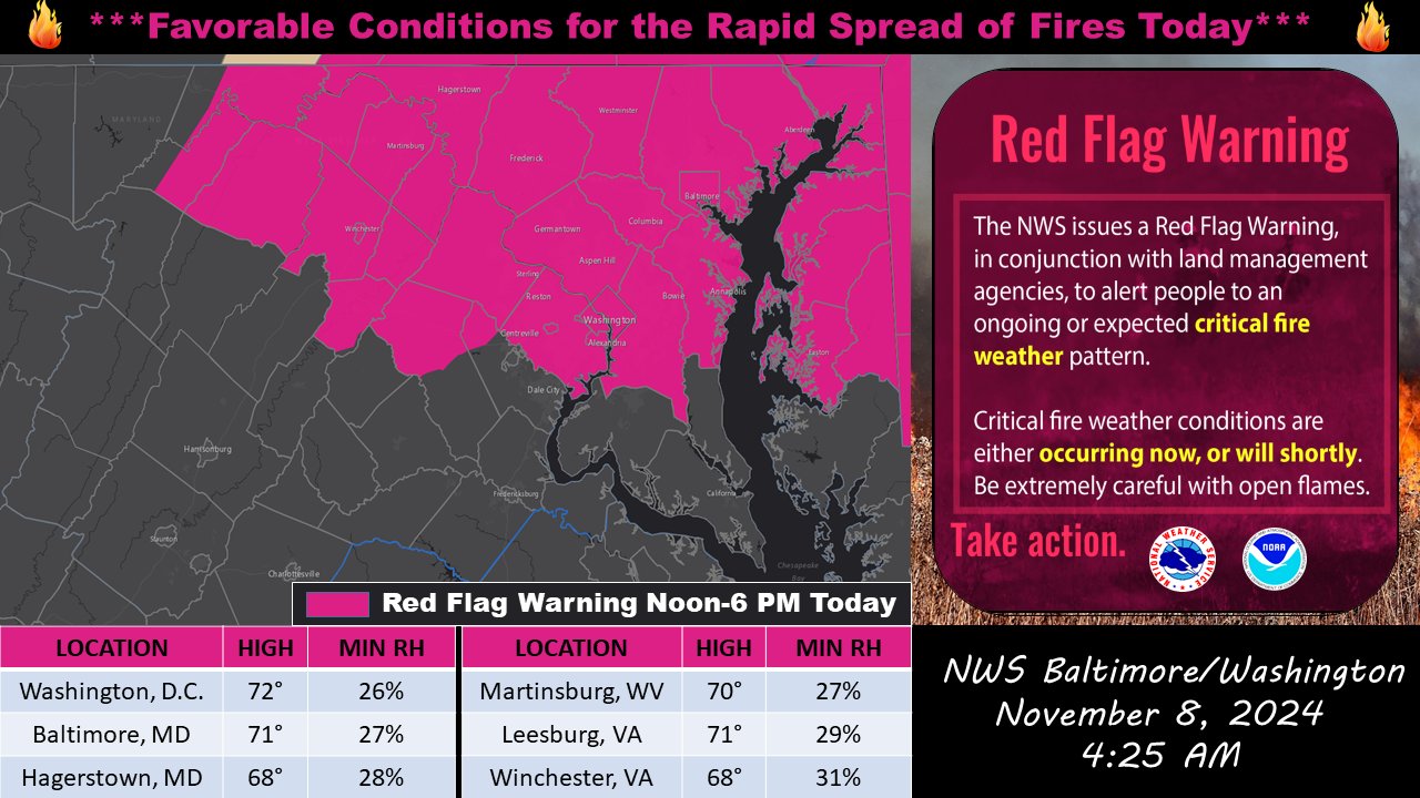
Due to dry conditions, low relative humidity and anticipated gusty winds, the U.S. National Weather Service (NWS)has issued an Elevated Fire Danger across most of Northern and Central Virginia today. As a result, the Stafford County Fire Marshal’s Office is implementing a ban on all outdoor burning for Friday, November 8th until 7AM Saturday, November 9th in Stafford County.
In addition to no open air burning, this is a friendly reminder to be extremely cautious when disposing of cigarette butts and matches and keep vehicles and equipment that could spark off of dry vegetation, like grass.
Original post — Good morning! Here’s a look at today’s weather forecast from the National Weather Service.
Yesterday’s cold front has moved down into the Carolinas, bringing cooler, drier air into our area. Early risers may have noticed some clouds, but they’ll clear out quickly, leaving us lots of sunshine and a breeze from the northwest. Temperatures will be mild, with highs reaching about 74°F. Gusty winds could pick up in the afternoon, especially in higher areas and north of US-50 and I-66, with gusts of 20-30 mph possible.
While it’s dry today, this windier weather is expected to continue into the evening, so take caution if you’re planning any outdoor fires, as conditions are primed for rapid spread.
Tonight, we’re looking at mostly clear skies, temperatures dropping to around 44°F, and a northwest breeze of 8-10 mph. Moving into Saturday, expect more sunshine but cooler temps, with a high near 59°F. Clouds will increase Saturday night as we head into Sunday, with the possibility of afternoon showers and temperatures near 60°F.
Enjoy the clear, crisp start to the weekend!
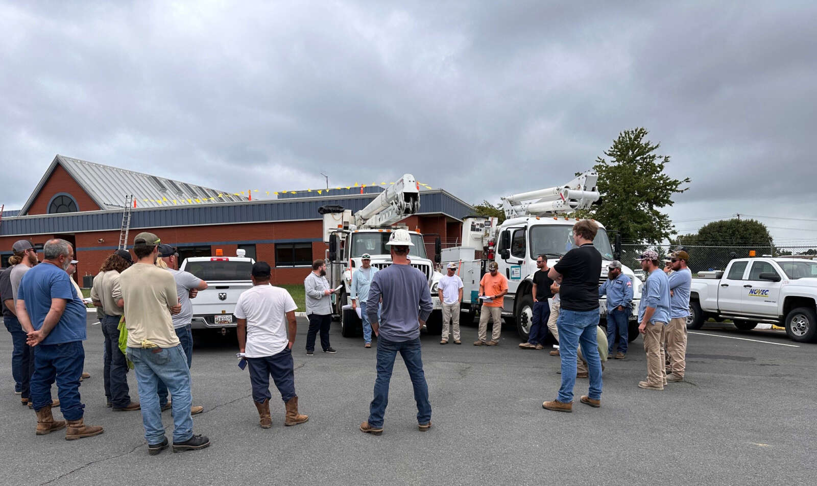
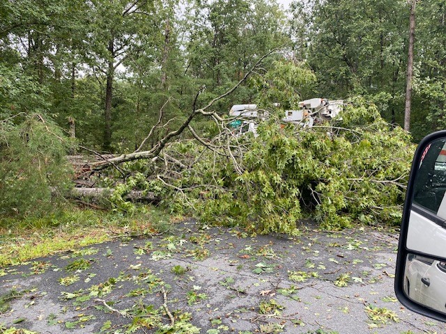
Crews from the Northern Virginia Electrical Cooperative (NOVEC), along with contractors and support from other electric cooperatives, continue to restore power after a severe storm that hit Northern Virginia on Thursday, August 29, 2024. The storm caused significant damage, particularly in Stafford County and southern Fauquier County, leading to widespread outages and extensive repairs.
As of 7 a.m. on Saturday, August 31, NOVEC reports that the number of customers affected by the storm has decreased from 6,000 to approximately 430. In Stafford County, crews are focused on replacing broken electric poles and repairing downed power lines. Replacing a single broken pole can take several hours, especially when trees are down, and the ground is saturated from heavy rain.
Damage assessment was completed on Friday, August 30, and line crews worked through the night to restore power to affected areas, including those in Stafford County. NOVEC crews have been joined by contractors and linemen from several organizations, including Choptank Electric Cooperative, Southern Maryland Electric Cooperative, Central Virginia Electric Cooperative, Prince George Electric Cooperative, Bayline Construction, River City, and Utility Lines Construction Services, LLC.
As of Friday evening, about 1,000 customers, many in Stafford County, were still without power. The storm caused significant damage to NOVEC’s infrastructure, with more than 30 electric poles broken and requiring replacement. The storm, which brought nearly seven inches of rain in one hour and winds ranging from 60 to 80 mph, caused widespread outages and damage to equipment.
NOVEC continues to provide updates on their progress through their website and the SmartHub app. Customers in Stafford and other affected areas can find the latest restoration estimates by checking NOVEC’s Outage Map or using the app.
The cooperative reminds customers in Stafford and beyond to report outages by calling 703-335-0500, logging in to SmartHub, or texting “#OUT” to 85700. Safety tips and additional information about the restoration process can be found on the NOVEC website.
Chris Strong from the National Weather Service Baltimore-Washington office noted the unusual nature of the storm, highlighting that “one of the biggest things that was more uncommon about that event was just how little wind there was in the general atmosphere for these storms to move around.” This lack of atmospheric movement allowed the storms to “evolve and develop in place,” leading to prolonged periods of heavy rain and persistent lightning across several areas.
Despite the severity, the region did not experience any tornadic activity. Strong explained that tornadoes generally require wind shear—an increase in wind speed and a change in direction at different altitudes—which was absent during this event. This contributed to the storm’s stationary behavior, causing extended weather disturbances over the same locations.
The storms resembled tropical-like conditions often seen in places like Florida, not Virginia. “It was much more tropical both in the soupy tropical air that’s the fuel for these storms to get going and the stagnant air around,” said Strong.
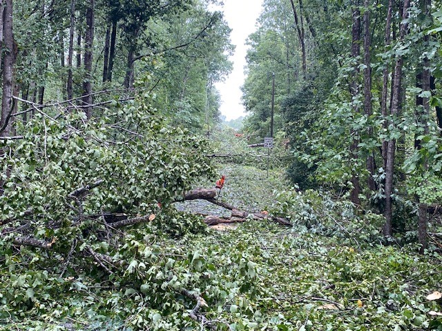
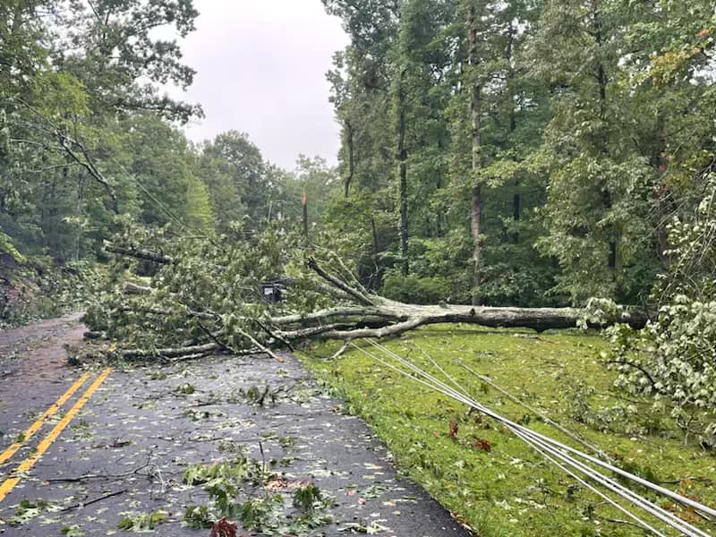
According to storm reports on file with the National Weather Service, emergency services in Prince William County were stretched as they responded to multiple calls related to the storm. At 6:32 p.m., a 911 call center reported approximately half a dozen trees down in the Buckland Mills area near Haymarket, causing obstructions and damage.
Flooding also became a significant concern, with the ramp from Route 29 onto Interstate 66 in Gainesville closed due to high water levels at 7:32 p.m. Further disruptions were reported in Dumfries at 8:31 p.m., where flooding across Route 1 impeded traffic flow.
Quantico Marine Corps Base recorded several high winds, with a peak 49 mph gust recorded on a Potomac River buoy at 8:35 p.m., illustrating the storm’s power as it moved over the area. Additionally, by 9:12 p.m., police closed Aden Road in Prince William County due to flooding.
More flooding was reported at 9:15 p.m. on Piper Lane near the railroad crossing near Manassas Regional Airport. There were several power outages, as well, with nearly 5,000 NOVEC customers out in Stafford County and more than 400 in Prince William.
Looking ahead, the region is now at the peak of hurricane season. Strong advised that while the current forecast suggests tropical disturbances will likely remain south of the mid-Atlantic, residents should remain vigilant through early October.
As Northern Virginia moves toward fall, Strong anticipates “more roller coasters of temperature swings,” providing some relief from one of the hottest summers on record.