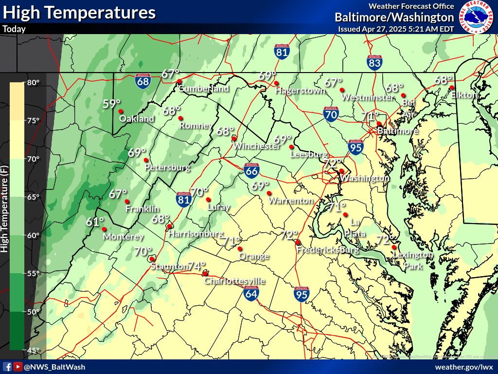
The workweek will begin on a cool and breezy note today, but it won’t last long. High pressure moving in from Canada will bring sunny skies and calmer conditions for Monday, followed by a sharp warm-up on Tuesday. A few showers and thunderstorms could develop late Tuesday as a warm front pushes through the region.
Here’s what to expect over the next few days:
- Sunday Afternoon: Breezy and cooler with plenty of sunshine. Highs will top out in the upper 60s to low 70s, but northwesterly winds could gust up to 35 mph at times. Humidity will be low, making it feel crisp and dry.
- Monday: A chilly start in the 30s and 40s will give way to a milder, sunny afternoon. Highs will reach the mid-70s with much lighter winds compared to Sunday.
- Tuesday: A warm front will move through, sending temperatures soaring into the low to mid-80s. Expect increasing clouds and the chance for a few afternoon and evening showers or thunderstorms, especially west of I-95.
- Tuesday Night: Very mild with temperatures holding steady in the low to mid-60s. Some showers could linger, mainly west of the immediate D.C. area.

A cold front moving through the area this afternoon and evening will bring scattered showers and a few thunderstorms. Some storms could be strong, with gusty winds. Behind the front, Canadian high pressure will bring cooler and breezy conditions for Sunday and Monday, with plenty of sunshine. Another weather system is expected to approach by midweek.
Weather Outlook:
- Saturday:
Scattered showers and thunderstorms this afternoon and evening. A few storms may be strong with gusty winds. Highs in the mid 70s to low 80s. Winds turning breezy after the cold front passes. - Saturday Night:
Showers ending after sunset. Cooler and breezy with lows in the 40s (upper 30s in the mountains). - Sunday:
Mostly sunny, breezy, and cooler. Highs in the mid 60s to low 70s. Winds gusting up to 30 mph. - Sunday Night:
Clear and chilly. Lows in the upper 30s to 40s. - Monday:
Sunny and a bit warmer. Highs in the low to mid 70s with light winds. - Tuesday:
Clouds increase with a chance of showers late in the day. Highs in the low to mid 70s.
 The National Weather Service has issued a Frost Advisory for many regions, warning residents that cold overnight temperatures could damage sensitive plants.
The advisory is in effect from 2 a.m. to 9 a.m. Thursday, April 17, covering much of central, northern, and northwest Virginia, portions of Maryland including northern and central counties, and parts of eastern West Virginia.
Temperatures are expected to dip to between 33 and 36 degrees, creating conditions favorable for frost to form. Tender vegetation, including spring flowers, garden plants, and early crops, could be harmed or killed if left unprotected.
Areas under the advisory include:
Central and northern Virginia counties, including Prince William, Stafford, Spotsylvania, and Fauquier
Residents are urged to take action tonight by covering sensitive plants or bringing them indoors if possible.
The cold snap follows a day of gusty northwest winds and cooler-than-average temperatures, and high pressure settling over the region overnight will allow for rapid cooling under clear skies.
Precautionary Tips:
- Cover outdoor plants with cloths, sheets, or frost blankets
- Move potted plants inside or into a sheltered location
- Water plants lightly before covering to help retain warmth
- Stay with Potomac Local News for the latest local weather updates.
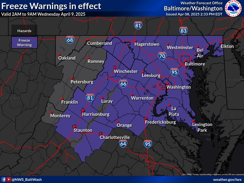
Residents across Northern Virginia and the surrounding region should prepare for a sharp plunge in temperatures tonight, with conditions expected to reach near-record lows. The National Weather Service reports that a powerful high-pressure system is moving into the area, ushering in clear skies, dry air, and cold temperatures through the middle of the week.
Forecasters say tonight’s weather will create “ideal radiational cooling conditions,” allowing heat from the ground to escape into the atmosphere. Low temperatures are projected to dip into the 20s for most areas, with some of the coldest locations possibly reaching the mid to upper teens. Urban cores like Fredericksburg and Manassas may stay around freezing, but are still expected to see unseasonably cold weather.
In response, the National Weather Service has issued Freeze Warnings for areas near and east of Interstate 81, excluding the Blue Ridge Mountains. The growing season in this region typically begins in early to mid-April, and recent mild weather may have prompted early budding, increasing the risk of cold damage to sensitive plants.
“This is an unusually strong cold snap for this time of year,” the weather agency noted. “We’re seeing temperatures 15 to 25 degrees below normal.”
On Wednesday, temperatures are expected to rebound slightly, with highs in the mid-50s under sunny skies. Winds will shift out of the south as the high-pressure system begins to move offshore.
Looking ahead to Thursday, an upper-level weather system will bring more unsettled conditions. Rain is likely to return as a warm front lifts into the region. Temperatures will rise back into the upper 50s and low 60s in areas south of the front, while communities to the north could remain cooler, with highs in the upper 40s to low 50s.
After a rainy end to the workweek, forecasters expect high pressure to return for the weekend, bringing drier weather and more seasonal temperatures.
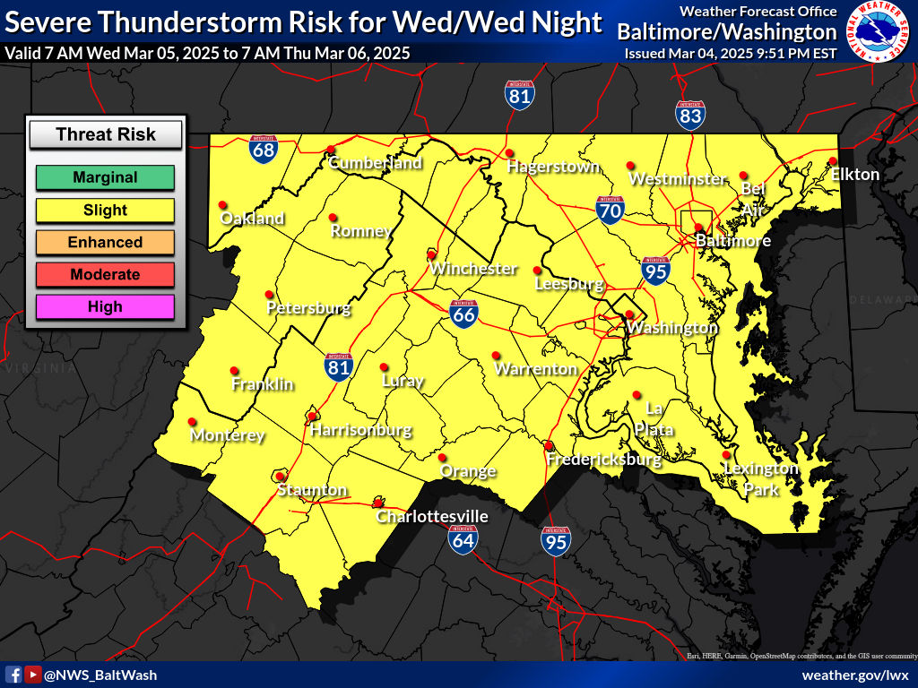
According to the National Weather Service (NWS), a potent weather system is set to impact the region today, bringing strong storms and gusty winds.
A deepening area of low pressure and an associated cold front will move across the region Wednesday, ushering in a line of showers and thunderstorms. Some storms may become severe, followed by a prolonged period of strong winds from Wednesday night into Thursday afternoon.
Severe Weather Timing and Potential Hazards
The NWS has adjusted its forecast to account for two rounds of potential severe weather on Wednesday. The first wave of storms is expected to arrive late Wednesday morning, primarily impacting areas along and west of the Blue Ridge between 11 a.m. and 1 p.m. The storms will then advance eastward toward metropolitan areas between noon and 4 p.m.
Meteorologists warn that damaging wind gusts will be the primary threat with this initial line of storms, with the possibility of isolated tornadoes embedded within the squall line. The second round of storms may develop later in the afternoon as a mid-level dry slot allows for renewed surface heating and instability. If additional storms do form, they could be supercellular in nature, posing risks of damaging winds, large hail, and a few tornadoes. The highest potential for these storms will be west of the Blue Ridge and along the Interstate 81 corridor.
Wind and Post-Storm Conditions
Gusty northwest winds will become the primary concern as the cold front clears the region late Wednesday night. Winds will strengthen throughout the area, with gusts reaching 30-50 mph, particularly on Thursday morning and afternoon. A Wind Advisory has already been issued for the higher elevations of the Alleghenies and the Blue Ridge, where gusts could reach 50 mph. Additional advisories may be required for other parts of the region.
Wintry Conditions in Higher Elevations
On the back side of the system, precipitation will linger over the mountains, transitioning to snow early Thursday. The western slopes of the Allegheny Front may see snow accumulations of 1-4 inches, which could cause hazardous travel conditions along the I-68 and US-219 corridors. Strong post-frontal winds will contribute to reduced visibility and blowing snow in these areas.
Looking Ahead
High pressure is expected to briefly build into the region on Friday, providing a break from weather before another low-pressure system and cold front move through on Saturday. As broad high pressure returns, more settled conditions are forecast for Sunday and into early next week.
Precautionary Measures
Residents are urged to stay informed and take precautions before the incoming weather system. Secure outdoor objects that strong winds could blow away, prepare for possible power outages, and remain weather-aware, especially if traveling in affected areas.

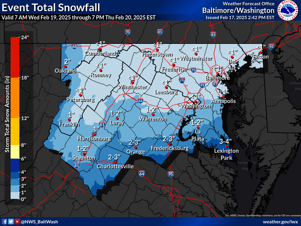
A winter storm bringing snow and strong winds will force schools in Stafford County, Fredericksburg City, and Spotsylvania County to close on Thursday, February 20, 2025.
Stafford County Public Schools will be closed, with all 12-month staff operating on a two-hour delay. As a result of this closure, Friday, March 21, 2025, will now be a regular, full instructional day for students to make up for the lost classroom time.
Fredericksburg City Public Schools (FCPS) will also be closed on February 20. It will be a Code Blue/Remote Learning Day. Students should not report to school but should participate in teacher-planned learning opportunities. All employees should work from home. Essential workers should contact their supervisor for report times.
All Spotsylvania County Public Schools are closed Thursday, February 20, 2025. CODE 3: Remote learning day for students. 12-month employees CODE 1.
Weather Forecast
According to the National Weather Service, a widespread band of snow showers is expected to push through the region Thursday morning, coinciding with the morning rush hour. This precipitation is associated with a potent upper-level trough moving through the area in the afternoon. Light snow accumulations are likely, with most areas expected to see less than an inch. However, given the frigid temperatures—ranging from the teens to the low 20s—slick spots on roads could create hazardous commuting conditions. A Winter Weather Advisory has been issued.
Winds will increase significantly as the system departs Thursday afternoon, with gusts reaching 30 to 50 mph, particularly in higher elevations. While wind advisories have not yet been issued, further updates may be necessary. Wind chills may approach Cold Weather Advisory criteria along the Allegheny Ridge, prompting additional weather precautions.
Parents and staff are encouraged to monitor official school communications for any further updates regarding schedule changes or additional closures.
Bitterly cold air is sweeping into the region, but the anticipated snowstorm will largely miss Northern Virginia. Instead, it will track south toward Williamsburg and Virginia Beach, where accumulations are expected to be significant.
According to the National Weather Service, an expansive Arctic high-pressure system is building into the north-central U.S., reinforcing the cold snap. Meanwhile, an area of low pressure developing over the Mississippi River Valley will move toward the Carolinas before heading offshore midweek. As a result, the heaviest snowfall will stay well to the south, sparing much of Northern Virginia, the Washington, D.C. area, and Maryland from significant impacts.
Frigid Temperatures Settle In
Though the region will miss the brunt of the snowstorm, the incoming Arctic air will make for a bitterly cold stretch. Low temperatures will dip into the single digits across higher elevations, with wind chills dropping to -10 to -15 degrees west of the Allegheny Front. Due to dangerously low wind chills, a Cold Weather Advisory is in effect for those areas.
Elsewhere, temperatures will fall into the mid-teens to mid-20s, with wind chills in the single digits and teens. While winds have diminished somewhat since the weekend, 20 to 30 mph gusts are still possible Tuesday, adding to the chill.
Snow Stays South, But Some Areas May See Flurries
Forecasters say the developing storm system will stay to the south, keeping most accumulating snow out of Northern Virginia and D.C. However, depending on the track and intensity of the system, parts of southern Maryland, particularly St. Mary’s County, may still see snowfall. A Winter Storm Watch has been issued for that area, where up to five inches of snow could fall.
Elsewhere, only a few flurries or light snow showers are possible late Tuesday into Wednesday, but no significant accumulation is expected.
Cold Continues Through the Week
After the storm passes, high pressure will take control, keeping conditions dry but cold through the end of the week. High temperatures will likely remain below freezing across much of the region, with nighttime lows plunging into the teens and single digits.
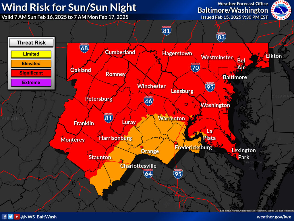
The National Weather Service has issued a High Wind Warning for much of the region. Strong winds are expected to develop Sunday morning and persist through Monday, with wind gusts reaching up to 60 mph in some areas.
The warning is in effect from 10 a.m. to 10 p.m. Sunday, with the strongest gusts anticipated in the afternoon and evening. Wind speeds of 20 to 30 mph with gusts of 50 to 60 mph are expected. These high winds could cause downed trees and power lines, leading to widespread power outages. Residents are advised to stay indoors, avoid windows, and secure outdoor objects.
Hazardous Travel Conditions
Motorists should exercise extreme caution, especially those driving high-profile vehicles, as travel conditions could be difficult. Wind gusts of 40 to 50 mph may continue into Monday, increasing the risk of flying debris and hazardous road conditions.
Looking Ahead: Possible Major Snowstorm Midweek
After the high winds subside, all eyes turn to the potential for a significant winter storm midweek. Meteorologists are tracking a coastal low-pressure system that is expected to form off the Carolinas on Wednesday, bringing snow to the region Wednesday into Thursday.
- Forecasters caution that the storm’s exact track is still uncertain. Still, some models suggest a major snow event with accumulations ranging from a few inches to over a foot in some areas. The heaviest snowfall is most likely from Wednesday afternoon through Thursday morning.
- Residents are urged to stay updated on forecasts as the storm approaches. Prepare now by:
- Securing outdoor items before Sunday’s high winds
- Checking emergency supplies, including flashlights and batteries
- Having a backup heating source in case of power outages
- Monitoring weather alerts for snowfall updates midweek
As always, stay tuned to Potomac Local News for updates on weather conditions and potential school or business closures as the storm develops.
Median Snow Totals by Region:
Fredericksburg:
- 6.5 inches
Manassas area:
- 9.5 inches
Prince William County:
- 7.8 inches
Stafford County:
- 7.8 inches
Spotsylvania County:
- 6.4 inches
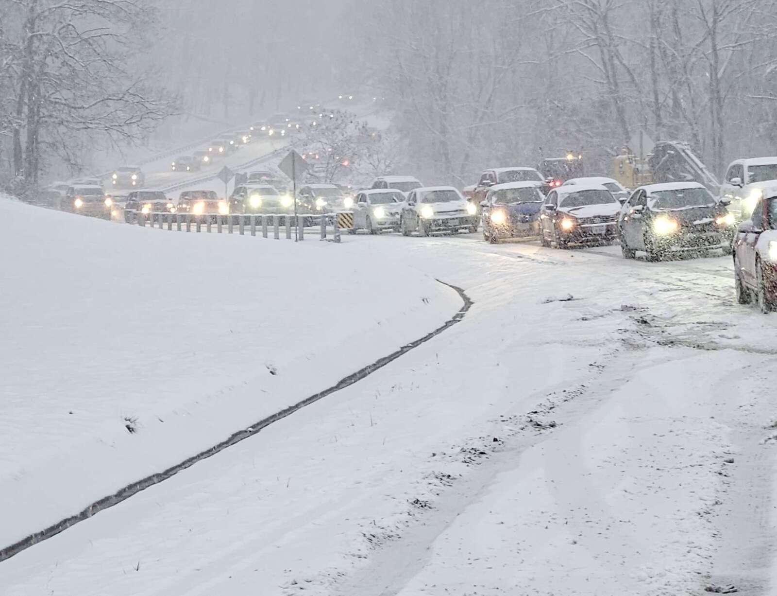
The heaviest snowfall totals were recorded in Manassas and parts of Stafford County, where accumulations neared 9.5 inches. Many roads across the region remain snow-covered and hazardous, prompting school closures and delays for Tuesday.
This article is FREE to read. Please Sign In or Create a FREE Account. Thank you.
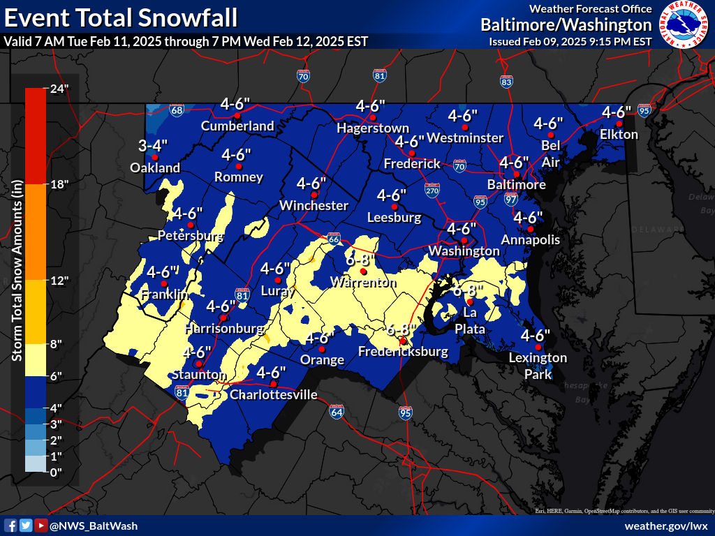
Updated – The National Weather Service (NWS) Baltimore-Washington office has issued a Winter Storm Watch for the region, warning of heavy snowfall and hazardous travel conditions from Tuesday afternoon through Wednesday morning.
Snowfall Forecast & Timing
Forecasters predict four to six inches of snow, with some areas possibly receiving higher totals.
- Tuesday Afternoon: Light snow begins across the region.
- Tuesday Evening into Overnight: Snowfall intensifies, becoming steady and heavy at times.
- Wednesday Morning: Additional wintry precipitation is possible before tapering off.
Impact on Travel & Commutes
The Tuesday evening and Wednesday morning commutes could be significantly impacted due to slippery and snow-covered roads. Drivers are urged to exercise caution and prepare for reduced visibility and potential delays.
Midweek & Weekend Weather Outlook
The active weather pattern will continue through the week:
- Wednesday: Snow transitions to a wintry mix, with freezing rain likely in areas west of the Blue Ridge Mountains and a rain/snow mix possible east of the mountains.
- Weekend: Another storm system may bring heavy rain or a wintry mix, increasing the risk of flooding as rain falls on a snow-covered landscape.
How Much Snow Will Fall? Guess & Win!
Think you can predict the total snowfall? Comment with your guess for the official snowfall recorded at Reagan Washington National Airport.
The first correct guess posted by 11:59 p.m. on Monday, February 10, 2025, wins a prize! The winner will be announced later this week.