
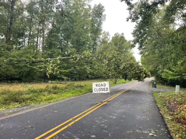
The Rappahannock Regional Solid Waste Management Board (R-Board) has announced that it will temporarily waive fees for yard debris disposal for residents until Sunday, September 8, 2024. This decision comes in response to the Aug. 30 storm that brought heavy wind and rain to Stafford County and surrounding areas. The storm, which marked the beginning of Virginia's hurricane season, resembled tropical-like conditions often seen in places like Florida, not Virginia.
Residents can take yard waste to two locations: the Regional Landfill on Eskimo Hill Road and the Belman Road Convenience Center. The Eskimo Hill location accepts limbs and debris up to 12 inches in diameter and eight feet in length. The Belman Road Convenience Center will accept debris up to four inches in diameter and eight feet in length.
This article is FREE to read. Please Sign In or Create a FREE Account. Thank you.
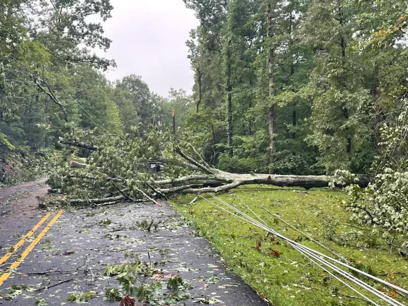
Yesterday's storm brought high winds and heavy rains to a wide area ranging from Spotsylvania to Maryland. Stafford County Sheriff's Office reports the Hartwood Area experienced heavy damage, with trees on power lines and Spotted Tavern Road closed due to hazards.
The National Weather Service reports Fredericksburg received between 2.2 and 2.9 inches. Prince William County ranged from 1.89 inches to 3.57; Woodbridge, Gainsville, and Nokesville all received over 3 inches of rain. Measurements at the Stafford Regional Airport showed 6.87 inches, and Falmouth received just over 4 inches. Fredericksburg received 2 inches.
This article is FREE to read. Please Sign In or Create a FREE Account. Thank you.
Chris Strong from the National Weather Service Baltimore-Washington office noted the unusual nature of the storm, highlighting that "one of the biggest things that was more uncommon about that event was just how little wind there was in the general atmosphere for these storms to move around." This lack of atmospheric movement allowed the storms to "evolve and develop in place," leading to prolonged periods of heavy rain and persistent lightning across several areas.
Despite the severity, the region did not experience any tornadic activity. Strong explained that tornadoes generally require wind shear—an increase in wind speed and a change in direction at different altitudes—which was absent during this event. This contributed to the storm's stationary behavior, causing extended weather disturbances over the same locations.
This article is FREE to read. Please Sign In or Create a FREE Account. Thank you.

Uriah Kiser, Founder and Publisher of Potomac Local News, has updated a video from the scene of tonight's storm, which has brought significant rain, lightning, and thunder to Prince William, Manassas, Stafford, and Fredericksburg.
Kiser has pulled over at a gas station and notes that traffic is moving slowly. Trucks, cars, and SUVs are all pulling over on the side of the road or driving slowly with flashers on. He said, "If you're at home, stay there."
This article is FREE to read. Please Sign In or Create a FREE Account. Thank you.
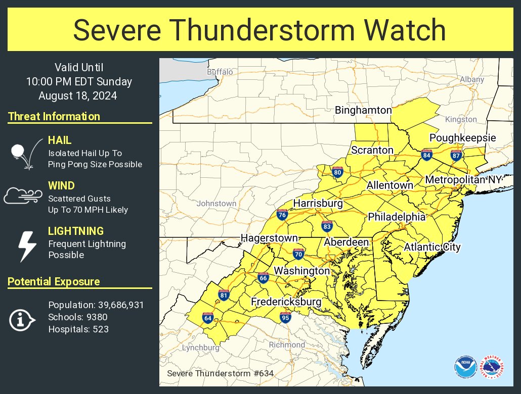
The National Weather Service has issued a severe thunderstorm watch for the region until 10 p.m. on Sunday, August 18. A slow-moving cold front will bring showers and thunderstorms throughout the day. The highest chances of precipitation are expected this afternoon and evening as the front moves across the area.
We can expect the storms to produce damaging wind gusts and isolated instances of flooding. The potential for large hail or an isolated tornado also exists due to increasing instability in the atmosphere, according to the National Weather Service.
A Flood Watch has also been issued from 2 to 8 p.m. this afternoon through this evening for parts of Northeast Maryland and the Washington, D.C. area. Some storms may produce rainfall rates of one to two inches per hour, leading to isolated instances of urban flooding in vulnerable areas.
Temperatures are expected to range from the 70s to 80s, with overnight lows dropping into the 60s to low 70s. After the cold front passes, dry conditions and cooler temperatures will return next week as high pressure builds in from the northwest.