![](https://www.potomaclocal.com/wp-content/uploads/2024/08/splashdown-water-park-600x314.jpg)
Prince William County
Lake Ridge Marina and Splashdown Water Park, near Manassas, are closed today due to severe weather conditions. Active tornado warnings and watches, combined with the forecast of high winds, heavy rainfall, and flooding, have prompted the closures.
Camps at Lake Ridge, Silver Lake, and Wingapo have also been canceled for the day. Camps at other locations will continue as scheduled.
The severe weather results from the remnants of Tropical Storm Debby, which is currently moving through the region. The storm has brought significant rainfall and high winds, leading to multiple tornado warnings being issued overnight. As of the morning of August 9, 2024, a tornado watch remains in effect until 2 p.m. for several counties and independent cities across Virginia.
Email [email protected] or text us at 571-989-1695 about your closures.
Friday, Aug 9 – Due to active tornado warnings/watches, the forecast for wind, continued heavy rainfall, and flooding, Lake Ridge, Silver Lake and Wingapo camps are all canceled. Camps at all other locations will operate as scheduled.
Lake Ridge Park Marina is also closed. pic.twitter.com/Fdu28QVHrH
— PWC Parks & Recreation (@PWCParks) August 9, 2024
Update — The tornado watch is canceled.
Original post — The remnants of Tropical Storm Debby are currently moving through the region, bringing significant impacts in the form of heavy rain, high winds, and multiple tornado warnings issued overnight. As of the morning of August 9, 2024, the tornado watch has been extended until 2 p.m. for several counties and independent cities across Virginia.
The National Weather Service warns people in multiple counties, including Arlington, Fairfax, Fauquier, and Stafford, as well as independent cities such as Alexandria, Fairfax, and Manassas, should be on alert.
A preliminary tornado was confirmed by the National Weather Service on Thursday, August 8, 2024, at 8 p.m. The tornado was reported in Stafford County, near Heflin. The report indicates that several trees were downed along Hartwood Road near Park Farm Lane. The tornado was preliminarily confirmed by dual-pol radar analysis, with a follow-up ground survey expected in the coming days.
The weather forecast for the remainder of the day indicates that the remnant low of Debby is moving rapidly north, nearing Elkins, West Virginia, as of 3:30 a.m. The associated shield of heavy rain has been lifting across western portions of the forecast area, with more isolated bands to the east. Rain will eventually become concentrated along a trailing surface trough and cold front, which is expected to move east by tonight.
The flash flood threat remains a concern due to the tropical airmass and potential for training rain bands. However, the overall threat is expected to diminish as the heaviest rain lifts to the north. A Flood Watch remains in effect for much of the area until 8 p.m., with additional watches in place for specific larger rivers.
The tornado watch, initially set to expire at 7 a.m., has been extended due to the possibility of renewed severe weather activity in the eastern half of the region as forcing for convection increases throughout the day. Residents in the affected areas are advised to remain vigilant and follow any updates from the National Weather Service.
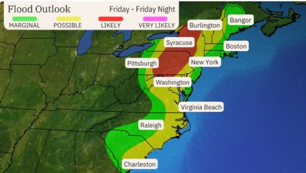
The National Weather Service has issued a Tornado Watch in effect from 6:19 a.m. to 2 p.m. on Friday, Aug. 9. The watch follows multiple reports of a tornado touching down in Caroline County yesterday evening.
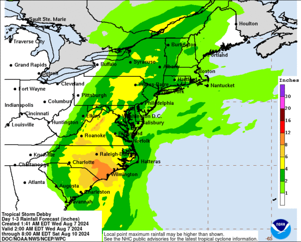
The storm is predicted to bring significant rainfall to the area, with risks of flooding possible. The Rappahannock River last flooded downtown Fredericksburg on Jan. 10, 2024. It crested at 19.1 feet at 5:30pm, impacting Old Mill Park and encroaching trails along Fall Hill Avenue. Fredericksburg has already closed Old Mill Park in anticipation of Tropical Storm Debby.
Fredericksburg: Tropical Storm Debby’s main system is moving north into Virginia from North Carolina. The current forecast track is that the main part of the storm will remain to our west, generally travelling from south to north along the Interstate 81 corridor. That said, the Fredericksburg area will see significant rainfall, with rain bands that could be heavy at times beginning mid-afternoon today, Thursday, through the overnight hours, and decreasing sometime around mid-afternoon tomorrow. This system has also spawned thunderstorm and tornado activity, so please stay alert and continue to monitor conditions in case those develop.
Here are some updates from the City of Fredericksburg, along with some tips and updates as the storm moves through Virginia:
- Old Mill Park, Alum Spring Park and the Dog Park are now closed due to wet conditions. Park staff is monitoring water levels and other parks could be closed due to high water levels or adverse conditions.
- Heavy rain to the west of Fredericksburg may lead to flood conditions for the Rappahannock River, even after the storm passes. Continue to monitor FredericksburgAlert.com or the City’s website at www.fredericksburgva.gov for the latest river conditions.
- City Staff from all departments have been preparing for Tropical Storm Debby and our Public Safety and Public Works teams are ready to respond.
- FXBGO! Transit operations are still on schedule at this time.
- City Government offices are open and will remain open as regularly scheduled.
Tropical Storm Debby is expected to bring two to three inches of rain, possible tornadoes, and wind gusts of 40-50 mph to our area. Significant inland flooding from the Occoquan River and local creeks such as Ballywhack Creek is likely. Occoquan Town staff prepare for the storm by stocking emergency materials and cleaning drainage grates. At the same time, residents are advised to exercise caution, report power outages, and stay alert for potential flash flooding and downed power lines.
From Occoquan Mayor Earnie Porta:
As many of you are probably aware, Tropical Storm Debby is expected to impact our area most heavily this evening through Friday. Projected impacts include 2-3 inches of rain, possible tornados, and wind gusts of 40-50 mph. Those of you who have lived in Occoquan for 10-15 years likely recall it is often less the winds that impact the town, but inland flooding from the prodigious amounts of rain that such storms may bring.
Of course, one source of such flooding is the Occoquan River itself. Yet thanks to the capabilities of Fairfax Water and others, the amount of potential flooding from both water coming over the dam (which does not and has never had any flood control gates) and water coming upriver from a tidal bore is fairly predictable, and riverfront property owners are generally well prepared, knowing that the occasional downside of a beautiful waterfront location is that the river will sometimes overflow its banks.
Much less predictable and a more consistent source of damage in town is flash flooding from the creeks that enter town, particularly Ballywhack Creek at Tanyard Hill Road. This is an inevitable feature of living in a riverfront valley, but over the last ten years a great deal of progress has been made in addressing flooding associated with the creek. Prince William County has retrofitted the storm water retention pond on LRPRA property to slow the water that flows into the creek from outside of town.
Typically, Prince William County also checks the catcher devices upstream from town before a storm to ensure they are clear of debris and ready to stop new debris that might flow downstream and block the culvert under Tanyard Hill Road. VDOT has also installed and deepened drainage trenches along the roadway to catch and redirect more water.
Video: Occoquan floods during Tropical Storm Alex in 2011
Heavy rainfall across portions of the Carolinas is expected to persist through today along with areas of considerable flooding. Heavy rainfall will also result in considerable to locally catastrophic flooding impacts across portions of the Mid-Atlantic States and Northeast… pic.twitter.com/tmQqE6qVMH
— National Weather Service (@NWS) August 8, 2024
The National Weather Service has issued a forecast indicating that Tropical Storm Debby will significantly impact our region with heavy rain and potential flooding. Residents should prepare for various weather conditions over the next few days.
Wednesday:
- Morning to Early Afternoon: Expect mostly dry conditions, with temperatures reaching the mid- to upper 80s in lower elevations and the upper 70s in the mountains.
- Late Afternoon to Early Evening: Showers and thunderstorms are expected to develop, increasing the risk of isolated flooding due to recent rainfall and partially saturated soil east of the Blue Ridge.
Overnight into Thursday:
- Showers and storms will persist overnight, with lows in the 70s near the waters and 60s further north and west. Winds will pick up, with gusts of 10 to 15 mph possible.
Thursday to Friday Night:
- Thursday: The remnants of Debby will begin to affect the area. Rainfall will start light to moderate, increasing by evening as Debby moves northward. The exact track remains uncertain, but expect a prolonged moderate to heavy rainfall from late Thursday night into Friday.
- Friday: The impact will depend on Debby’s track. Rainfall amounts could range from 3 to 7 inches, with localized areas receiving up to 10 inches, especially in central Virginia. Areas further north and east might see 2 to 4 inches, with localized areas up to 7 inches.
Weather Threats:
- Flooding: Due to the expected rainfall totals, a flood watch may be issued, particularly if heavy banding sets up over specific areas.
- Tornadoes: A conditional threat exists for tornadoes, particularly east of the storm’s center.
- Wind: Gusts of 20 to 30 mph are expected, with stronger gusts possible in thunderstorms, particularly on the eastern side of Debby’s circulation.
Conclusion:
- The remnants of Debby will continue to move northeast Friday night into Saturday morning, with impacts subsiding by Saturday. Overnight lows will range from the upper 50s along the Allegheny Front to the 60s and low 70s toward the waters.
The City is preparing for the potential impacts from Tropical Storm Debby.
Here is how you can prepare:
-Clear your outdoor drains & ensure that your sump-pump is working.
-Secure outdoor furniture.
-Sign up for Emergency Alerts from the City by going to: https://t.co/bFiH4If4Wn— CityofManassasPark (@ManassasParkGov) August 7, 2024