MANASSAS — (From Email)Â The Prince William County Office of Emergency Management asked us to share the following information and I am asking you to help by sharing it too:
- All residents are asked to review or build an emergency supply kit and communications plan for their family, then sign up for emergency alerts. Instructions are at www.pwcgov.org/ready
- Official county updates will be posted to the Emergency Information Portal at https://emergency.pwcgov.org Â
- The official forecast for Florence is issued by the National Hurricane Center via www.hurricanes.govand impacts will be felt far outside the forecast cone.Â
If Volunteer Prince William is asked to activate, we will contact our registered disaster volunteers via email or telephone for specific needs requests. First and foremost, take safety measures now to prepare – keep yourself and your family safe (including pets) – see the web links above.
Volunteer Prince William does not make the decision to activate volunteers. We are instructed to do so only by Emergency Management officials. Volunteers will not be activated until conditions are deemed safe enough to be out and about.
If you are interested in serving your community as a disaster volunteer, please review your account on our website: volunteerprincewilliam.org and make sure you have indicated as much on your registration page.
Please be patient. It is possible we may not be asked to activate any volunteers. If you want to help and are unable to volunteer there will be instructions, as necessary, about donating cash. Please DO NOT make any plans to donate items that are not SPECIFICALLY requested. Instructions will be posted should we be requested to fill unmet needs. Stay tuned and stay safe!
RICHMOND—(Press Release) Governor Ralph Northam this evening issued a mandatory evacuation order for coastal Virginia residents in Zone A in advance of Hurricane Florence, effective Tuesday, September 11 at 8 a.m.Â
Zone A includes low-lying areas of Hampton Roads and the Eastern Shore. Residents of Zone A are urged to move to higher ground. Information about shelters will be available soon.Â
“Hurricane Florence has the potential to cause catastrophic flooding, especially in our coastal areas,” Governor Northam said. “This evacuation is for the safety of thousands of Virginians living in that zone. But the effects of this storm will be felt statewide, and I encourage everyone in Virginia to prepare now.”
Governor Northam’s decision to call for a mandatory evacuation was based on the most recent data and forecasts available, which show the potential for flooding in coastal areas.
While the storm’s track may still change, the models agree that Virginia can expect significant impacts—coastal storm surge, inland flooding that may be severe, high winds, and widespread power outages.
Virginians in coastal areas can see which zone they live in by going to knowyourzoneva.org.
Governor Northam has declared a state of emergency for Virginia, to begin preparation of state assets. Also on Monday, Governor Northam requested a federal emergency declaration in advance of the storm, to ensure the availability of federal resources to help Virginia with storm response.
Governor Northam orders the coastal evacuation of Zone A, the lowest-lying areas of Coastal Virginia and the Eastern Shore, effective 8 a.m. tomorrow (9/11).
Call 2-1-1 to learn your zone or visit https://t.co/sDaOdlw0qy.
Zone A residence should move to higher ground. pic.twitter.com/PupNQLvUNL
— VDEM (@VDEM) September 10, 2018
Dam owners in Virginia are advised to consult with a professional engineer about possibly lowering lake levels by up to 6 inches per day ahead of Hurricane Florence. From the Virginia Department of Conservation and Recreation (DCR) press release:
Advisory to Virginia Dam Owners ahead of Hurricane FlorenceÂRICHMOND, Va. — As of Monday Sept. 10, the National Weather Service has forecasted the potential for a major hurricane-level storm event in Virginia within the next week. Rainfall projections are currently forecasted to be from approximately 10 to 20 inches in some areas of the state if the storm were to slow down or “stall.”ÂIn preparation for this potential storm event, the Virginia Department of Conservation and Recreation Dam Safety Program is offering the following information to dam owners.Â1. Reach out to your professional engineer and discuss the specifics of your dam and what to do during an emergency situation.2. Locate and review your dam’s emergency action plan if one is in place. Ensure that all contacts and contact information are up-to-date. Provide any updates to the local emergency services contact and DCR Dam Safety.3. If your dam has a working low-flow valve, you as the dam owner should consider consulting with your professional engineer about possibly lowering your lake level by up to 6 inches per day (24-hour period). By lowering the normal water level in your lake, you provide extra storage for when rainfall begins. Note that lowering lake levels by more than 6 inches per day is not allowed as rapid drawdown of a lake level could result in critical damage to your dam.4. Visually inspect your dam and remove any debris from the primary and emergency spillways. Contact your professional engineer if any dam-related issues are found (seepage, slope failures, rodent holes, etc.)ÂFor information about the Virginia Dam Safety Program, go to https://www.dcr.virginia.gov/dam-safety-and-floodplains.
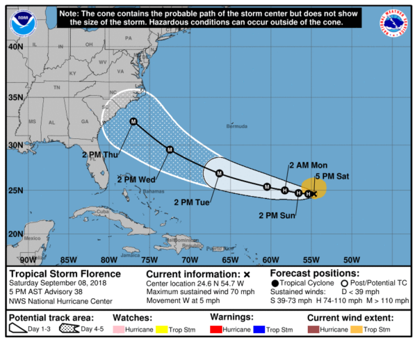
RICHMOND— (Press Release) Governor Ralph Northam declared a state of emergency today in anticipation of the potential impact from Tropical Storm Florence. The order is designed to mobilize resources in preparations of the storm and to help Virginia mitigate any damage and to streamline the process that the Commonwealth uses to provide assistance to other states vulnerable to Florence.Â
“While the impacts of Tropical Storm Florence to Virginia are still uncertain, forecasts increasingly expect the storm to strengthen into a major hurricane that could seriously affect the East Coast and Virginians,” said Governor Northam. “Accordingly, I am declaring a state of emergency so that we can begin to prepare state assets, and I encourage Virginians to monitor forecasts and make their own preparations now.”
A state of emergency allows the Commonwealth to mobilize resources, including the Virginia National Guard, and pre-position people and equipment to assist in storm response and recovery efforts.
While the track of Tropical Storm Florence is still uncertain, it appears increasingly likely that Virginia may see significant impacts from this storm next week. Impacts include possible flooding, high winds, and potential storm surge.Â
The Governor’s Office, the Virginia Department of Emergency Management (VDEM), the Federal Emergency Management Agency (FEMA), the Virginia National Guard, the Virginia State Police, and other state agencies have already begun preparations for the impacts of Tropical Storm Florence.
State agencies are working closely with localities to identify any needs in advance of the storm, and to pre-position resources where they will be most effective. The state Emergency Operations Center will be staffed next week in preparation for the storm and will transition into 24/7 operations as needed when the storm approaches.
Due to the uncertainty of the storm’s track this many days in advance, VDEM encourages all residents of Virginia to prepare for impacts from this storm. These can range from high winds and storm surge in coastal Virginia to significant flooding both along the coast and in rivers and streams in the western part of the state. Citizens should remember that flash floods could happen at any time and that flooding is the most deadly and damaging part of any hurricane.
Virginians should remember to “turn around and don’t drown.” Do not drive across any flooded roadway, as it only takes six inches of water to move a vehicle and roads may be washed out beneath the floodwaters.
In advance of the storm, assemble your emergency kit including food, water, medications, pet supplies and important documents that you will need to take with you if asked to evacuate in short order. To learn more about what to include in your emergency kit and how to prepare for hurricanes, visit www.VAemergency.gov/hurricanes.
It is also important for residents of Coastal Virginia to “Know Your Zone” before this storm impacts Virginia. If you live in Hampton Roads, the Middle Peninsula, Northern Neck or Eastern Shore, learn which new hurricane evacuation zone you live in by visiting www.KnowYourZoneVA.orgÂ
Stay tuned to local media in the coming days to keep close tabs on Hurricane Florence as it approaches the Commonwealth. Be prepared to take action, and know that storm forecast can vary significantly over just a few hours.
Lower temperatures and possibly heavy rainfall accompanying thunder storms are likely Thursday through Saturday.
Showers continue along western shore areas this afternoon. Temps are below seasonable values. Possible isolated shower as far west as DC. pic.twitter.com/9fXtuY4KGu
— NWS DC/Baltimore (@NWS_BaltWash) July 26, 2017
From the National Weather Service:
Widespread showers and thunderstorm are likely Friday and Friday night. Scattered incidents of flash flooding are possible from torrential downpours. Isolated severe thunderstorms are possible as well.
The temperature is expected to climb into the upper 90s Thursday through Sunday, according to the National Weather Service. Friday and Saturday are expected to be the hottest days, with heat indices around 100 degrees Fahrenheit.
Heat and humidity will be on the rise through the rest of the week and into the weekend, with the hottest days likely to be FRI & SAT. pic.twitter.com/GhiPn2TBTl
— NWS DC/Baltimore (@NWS_BaltWash) July 19, 2017
The National Weather Service also issued an Air Quality Alert for today:
The Metropolitan Washington Council of Governments in association
with Maryland Department of the Environment, Virginia Department
of Environmental Quality, and District Department of Environment
has issued a Code ORANGE Air Quality Alert Wednesday for
the DC metro area.A Code Orange Air Quality Alert means that air pollution
concentrations within the region may become unhealthy for
sensitive groups. Sensitive groups include children, people
suffering from asthma, heart disease or other lung diseases and
the elderly. The effects of air pollution can be minimized by
avoiding strenuous activity or exercise outdoors.
Following Thursdays rain and thunderstorms, the sun came out illuminated not one but two rainbows.
[ngg_images gallery_ids=”737″ display_type=”ds-nextgen_royalslider”]
Winter Weather Advisories for late tonight and Saturday expanded. Snow in the advisory approximately 1-3 inches, 3-6 inches in the warning. pic.twitter.com/irzUo7daBD
— NWS DC/Baltimore (@NWS_BaltWash) January 6, 2017
From the National Weather Service Baltimore/Washington office, updated 5:10 p.m. Friday:
Not much on radar at this time, though increasing coverage over the Great Smokies is making the 12Z GFS look more reliable. The surface low is not apparent yet, but should be developing over the western Gulf of Mexico. We are on the wester fringe of this storm with the surface low remaining off the Carolina coast and pushing NE from off Hatteras. Dry and cold air being drawn into the storm will limit snow for a majority of the LWX CWA. However, after midnight, swaths of snow will overspread southern and eastern portions of the area. The winter weather advisory was expanded to include central MD as well as the central Shenandoah Valley. 12Z guidance went a little farther west and the western edge will be tight, so these areas were the greatest targets at this time.
Snow will taper off from the west Saturday morning through the early afternoon. Snow ratios look to be 12-15 through the event across the area. So any shift with the storm edge will greatly affect snow totals.
North to northwest winds will remain up through the night with gusts 25 mph. Min temps teens west and low 20s east.
...WINTER WEATHER ADVISORY IN EFFECT FROM 1 AM TO 1 PM EST SATURDAY... THE NATIONAL WEATHER SERVICE IN BALTIMORE MD/WASHINGTON HAS ISSUED A WINTER WEATHER ADVISORY FOR SNOW... WHICH IS IN EFFECT FROM 1 AM TO 1 PM EST SATURDAY. * PRECIPITATION TYPE...SNOW. * ACCUMULATIONS...1 TO 3 INCHES. * TIMING...OVERNIGHT THROUGH MIDDAY SATURDAY. * IMPACTS...SNOW ON ROADS WILL RESULT IN TRAVEL IMPACTS. * WINDS...NORTH 10 TO 15 MPH WITH GUSTS UP TO 25 MPH. * TEMPERATURES...IN THE MID 20S. PRECAUTIONARY/PREPAREDNESS ACTIONS... A WINTER WEATHER ADVISORY FOR SNOW MEANS THAT PERIODS OF SNOW WILL CAUSE PRIMARILY TRAVEL DIFFICULTIES. BE PREPARED FOR SNOW COVERED ROADS AND LIMITED VISIBILITIES...AND USE CAUTION WHILE DRIVING.