
Residents across the area are preparing for a major winter storm that is expected to bring significant snowfall beginning this evening and continuing into Tuesday. The National Weather Service has upgraded Winter Storm Watches to Warnings, signaling potential snow accumulations of 5 inches or more in many areas.
Current Conditions
The day began with sunny skies, but clouds are expected to increase throughout the afternoon as a powerful winter storm system approaches Oklahoma. High temperatures today will remain in the 30s, with colder conditions in higher elevations. Gusty west winds persist but are less intense than previous days.
Storm Timeline
This evening, snow may begin in the southwestern parts of the region after 3 p.m., though most areas will see precipitation start closer to 6 p.m. or later. Overnight, snowfall rates could reach 1 to 2 inches per hour during the storm’s peak intensity late tonight into Monday morning.
Snow will continue through Monday morning before becoming lighter in the afternoon as the storm weakens. A secondary burst of moderate to heavy snow is possible Monday night as the system’s upper-level low moves overhead. By Tuesday, lighter upslope snow showers may linger, with widespread refreezing expected overnight as temperatures drop into the teens.
Snowfall Predictions
The storm’s exact impact depends on several factors, including where the heaviest snow bands form and how far north warmer air intrudes. Northern Maryland could see lighter snowfall or potentially some of the highest totals if the northern snow bands intensify. Areas near the I-66 corridor may experience some mixing of sleet or freezing rain, reducing snow totals. Central Virginia and southern Maryland are expected to see the heaviest snowfall, potentially nearing a foot in some locations.
Refreezing and Road Conditions
With temperatures dipping into the teens Tuesday night, widespread refreezing of untreated surfaces is likely, creating hazardous travel conditions. Residents are urged to stay off the roads during the storm and prepare for potential disruptions.
We’ll be posting more storm-related news in the coming hours, so stay tuned.
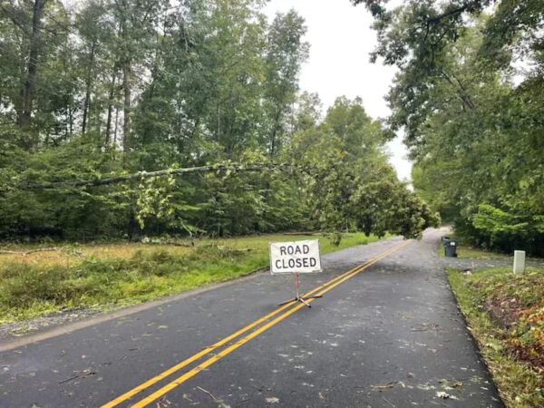
Yesterday’s storm brought high winds and heavy rains to a wide area ranging from Spotsylvania to Maryland. Stafford County Sheriff’s Office reports the Hartwood Area experienced heavy damage, with trees on power lines and Spotted Tavern Road closed due to hazards.
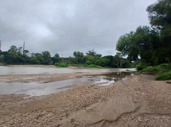
The National Weather Service reports Fredericksburg received between 2.2 and 2.9 inches. Prince William County ranged from 1.89 inches to 3.57; Woodbridge, Gainsville, and Nokesville all received over 3 inches of rain. Measurements at the Stafford Regional Airport showed 6.87 inches, and Falmouth received just over 4 inches. Fredericksburg received 2 inches.
No flood warning has been issued for the Fredericksburg area in anticipation of the Rappahannock River rising. As of noon Friday, water levels were low.

The National Oceanic and Atmospheric Association showed reports of hail in Stafford County and Loudon. Numerous trees and downed power lines have been reported throughout the region.
Spotsylvania County Public Schools closed Courtland High School, Courtland Elementary, Courthouse Road Elementary, and Spotsylvania Middle School late this morning. Some students had already boarded buses and were being returned to their homes.
Heavy rain during July and August and a major hurricane in the forecast have contributed to schedule adjustments for several drainage and road repairs in Stafford County. From the press release:
RAIN AFFECTING ROAD REPAIR PROJECTS IN STAFFORD COUNTY
Progress toward completion of several drainage, slope repair and pipe replacement projects has been hampered by more rain over the past weekend and the threat of more storms FREDERICKSBURG, Va. –
Heavy rain during July and August and a major hurricane in the forecast have contributed to schedule adjustments for several drainage and road reconstruction projects in Stafford County. Virginia Department of Transportation (VDOT) crews are adjusting project completion dates and start dates on several projects:
Route 631/Bells Hill Road
Route 631 (Bells HillRoad) closed to through traffic June 4 between Virginia Belle Drive and Belle Vine Lane for a slope failure and road damage caused by flooding. The road was scheduled to re-open to traffic in mid-September, but VDOT and contractor crews will require several additional weeks to complete the repair. Bells Hill Road is anticipated to remain closed until mid-October. Road closed barricades and detour signs to guide motorists remain in place. Bells Hill Road remains open at both intersections with Route 1.
Brooke Road
Work to stabilize a slope supporting a section of Brooke Road between Camp Geary Lane and Marlborough Point Road has been postponed until mid-October. The contractor working on Bells Hill Road will also stabilize the slope on Brooke Road. When work is complete on Bells Hill Road, the contractor can mobilize on Brooke Road.Telegraph Road Drainage Improvement Project
Installation of a drainage pipe project on Telegraph Road between Route 1 and the I-95 overpass continues. The road is scheduled to remain closed to through traffic at the I-95 overpass through late fall 2018.Parkway Boulevard
Work to replace a drainage pipe on Parkway Boulevard at Wellington Court has been postponed until a later date. New work dates will be announced. Parkway Boulevard will remain open to traffic this week.
From the University of Mary Washington:
We have been actively monitoring the path of Hurricane Florence. In a conference call this evening, education officials across the state agreed that a storm of this magnitude – which is likely to produce severe flooding, high winds, and widespread power outages – can present a danger to many locations, including our campus community.
As a result, the University of Mary Washington will close all of its campuses at 5 p.m. Wednesday, Sept. 12. All classes and University events will be canceled, and academic buildings will be locked. Only essential personnel should report to work. More information will be forthcoming, but the University is slated to reopen on schedule Monday morning, Sept. 17.
Provisions are being made to support those students who must remain on campus. You are urged to personally begin storm preparations, including the following:
— Ensure that your mobile devices remain fully charged.
— Refill prescription drugs.
— Gather basic supplies, such as food, a flashlight, and water to sustain yourself for several days, if you plan to remain on campus.
— If you have a car, fill it with gas.
For information on Florence’s path, access https://www.ready.gov/hurricanes. We will be regularly communicating updates as they are available. Please check umw.edu and/or the campus information line: 540-654-2424. The University’s No. 1 priority is the safety and comfort of our students.
From Novant Health/UVA Health System in Manassas and Haymarket:
Novant Health UVA Health System has a thorough emergency operations plan and practices the plan via drills held multiple times each year. We activated our Emergency Operations Plan on Monday, Sept. 10 for planning in preparation for the potential impact from Tropical Storm Florence in the Virginia market.
Critical systems and infrastructures have been assessed and steps taken to ensure have continued operations throughout the impact. Emergency Power generation at the hospitals is in place and has redundancy.
Additional fuel, supplies, food, water and medicines are being brought in as preparation continue.
Leaders are meeting regularly with Novant Health Emergency Management, Prince William County and Manassas City Emergency Management groups to update planning efforts.
Novant Health UVA Health System has engaged the National Weather Service and has a contract with a private weather forecasting vendor to ensure the most up to date information is available for decision making. We are prepared and ready to serve our communities as needed.
From Sentara Northern Virginia Medical Center in Woodbridge:
Being a hospital that deals with life and death situations every day, we’re constantly prepared for emergencies.
Like most of the east coast, we’re keeping an eye on the storm system, following forecast models and word from the National Weather Service.
We’re readying food, water, power and supplies to make sure we have a surplus. We’re topping off generators and making sure they run, checking backup systems and cleaning drains (to make sure they don’t back up with all this rain.)
In addition, Sentara Healthcare has developed a website to share up-to-date information,please continue to check www.sentara.com/weather for the latest.
In the meantime, we’re sharing this information from The National Hurricane Center with both the community and the members of our team so they can prepare for whatever weather may come our way, Hurricane Preparedness Supplies Kit check list: https://bit.ly/2O5va71.
From Prince William County Pubilc Schools:
We have not made any plans to cancel school at this point. However, we will continually monitor the weather forecast and frequently communicate with the Prince William Office of Emergency Management for updates. We also have an agreement with the Office of Emergency Management to provide schools as emergency shelters, if needed.
As far as preparations, please see below:
This article is FREE to read. Please Sign In or Create a FREE Account. Thank you.
OCCOQUAN — Town officials in Occoquan are not being caught off guard ahead of Hurricane Florence.
Mayor Earnie Porta tells us sandbags are being filled at the Vulcan Quarry next to the town along the Occoquan River in Prince William County.
Residents need to bring their own bags.
From an email:
As you are no doubt aware, the region is bracing for the arrival of Hurricane Florence Thursday evening. Between now and then more information will be forthcoming regarding storm preparations in Town as well as recommendations on storm preparedness.
In the meantime, our neighbor Vulcan Materials has agreed to provide sand for sand bags free of charge to town residents and businesses who believe this will assist in prevent flooding of vulnerable low-lying areas. They do not have bags, however, which individuals will have to purchase elsewhere and bring to fill themselves.
If you wish to take advantage of this opportunity you will need to go to the quarry, sign a waiver, and load the sand. For anyone who is unable to do this themselves, I and some volunteers are willing to provide assistance.
Please note that this is not a Town initiative, so please do not contact Town Hall to request staff assistance in this effort — staff will be busy making other preparations for the storm.
Instead, if you need assistance or are interested in volunteering to help, please email me directly at [email protected] or text me at 571-276-8695.
MANASSAS — Organizers have canceled this year’s Arts Alive festival ahead of Hurricane Florence.
From an email:
The Arts Council event committee and the Hylton Performing Arts Center has decided to cancel Arts Alive due to the pending Hurricane. At this point, we do not have a date to reschedule this event – will keep you posted should this happen.
The festival was to take place this Sunday at the Hylton Performing Arts Center in Manassas.
The festival features hands-on art displays for children and adults, as well as entertainment on four stages both inside and outside of the performing arts center.
At least 2,500 people attended the festival last year, according to the event website.