
 Prince William Parks and Recreation sponsors today’s weather forecast.
Summer Job Alert: Parks and Recreation Hiring Seasonal Workers Now! Want to earn some extra cash this summer and enjoy your job at the same time? PWC Parks and Recreation is now hiring for seasonal jobs.. Camp Counselors, Lifeguards, Cooks and more…
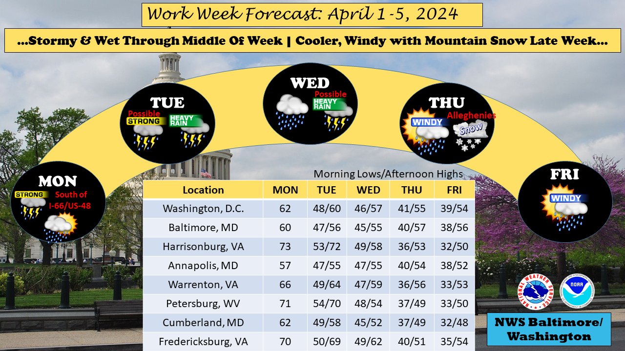 The National Weather Service warns of prolonged unsettled weather for the Mid-Atlantic region as a frontal boundary remains stationary, inviting multiple waves of low pressure. This weather pattern, persisting through midweek, promises to bring showers, thunderstorms, and potential flooding concerns to areas spanning from the central Plains to the Mid-Atlantic.
Today, residents can expect scattered showers throughout the morning, intensifying into likely showers and thunderstorms by late afternoon and evening. With temperatures reaching a high near 68°F, the day will be marked by cloudy skies and variable winds. Rainfall amounts are expected to be less than a tenth of an inch, though higher amounts are possible in thunderstorms.
Tonight, we’ll see continued showers and thunderstorms, with rainfall likely to persist into the early hours of Tuesday morning. Patchy fog is forecasted after 11 PM, with temperatures dropping to around 50°F. The chance of precipitation is at 80%, with new rainfall amounts projected between a tenth and quarter of an inch, potentially higher in areas experiencing thunderstorms.
More rain is likely Tuesday throughout the day and the possibility of thunderstorms after 11 a.m. Patchy fog may persist into the morning hours, with temperatures reaching a high near 64°F. The chance of precipitation stands at 70%, with anticipated rainfall amounts between a quarter and half of an inch.
Tuesday night offers little respite, as rain and thunderstorms continue, accompanied by patchy fog after 11 PM. Temperatures are expected to drop to around 49°F, with an 80% chance of precipitation and new rainfall amounts projected between a quarter and half of an inch.
Wednesday’s outlook mirrors the preceding days, with rain likely and the potential for thunderstorms. Cloudy skies persist, with temperatures reaching a high near 60°F. The chance of precipitation remains at 70%.
In anticipation of significant rainfall over the next few days, a Flood Watch has been issued for the westernmost counties, effective through late Tuesday night. Forecasters warn of the potential for 2 to 4 inches of rain, with localized higher amounts possible, raising concerns for flooding in saturated areas. Residents are advised to stay informed and prepared for changing weather conditions and to exercise caution when traveling in affected areas.
