
It’s been 11 years since the derecho wreaked havoc on our region, knocking out power and water for residents in our region for days.
The storm blew through on June 29, 2012.
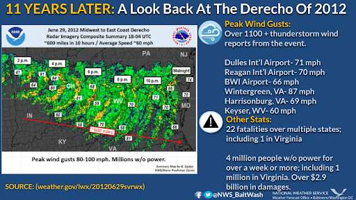
National Weather Service Baltimore-Washington: “Widespread damage was observed across nearly the entire area. This included observed wind gusts up to 80-85 mph. For an interactive summary: http://tinyurl.com/bdaeh22t”
Here’s a look back at our coverage from June 2012 with photos and power outage maps.
National Weather Service the derecho of June 29, 2012: “Essentially, a ‘derecho’ is a long-lived, rapidly moving line of intense thunderstorms that produces widespread damaging winds in a nearly continuous swath.”
“Because derechos are not common in our region, the term is relatively unknown to residents in the Mid-Atlantic. Typically, our region averages a derecho about once every 2 to 4 years.”
“A derecho can easily cover large portions of a state or multiple states. They often take on a curved or bowed shape. [June 29, 2012 derecho] appears to have originated from thunderstorms that developed along an east-west oriented stationary front over Iowa and northern Illinois on [that] morning.”