
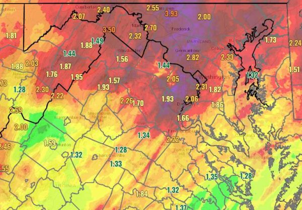
More than two inches of rain fell in portions of Prince William and Stafford counties this past weekend, one of the soggiest in at least a year. The heaviest rains fell Friday and Saturday, May 6 and 7, leaving behind a gloomy and cool Mother’s Day.
Rainwaters caused water levels in the Potomac River to rise. A Coastal Flood Advisory remains for King George County until 1 a.m.
Tidal flooding will likely continue through Tuesday, especially over DC as freshwater moves in from the upstream Potomac River. River flooding also continues through the day. Today will be milder with more sunshine after a couple dreary days. #MDwx #VAwx #DCwx #WVwx pic.twitter.com/QlFTFk30aX
— NWS Baltimore-Washington (@NWS_BaltWash) May 9, 2022
…COASTAL FLOOD ADVISORY IN EFFECT UNTIL 1 AM EDT TUESDAY…
* WHAT…Up to one half foot of inundation above ground level in
low lying areas due to tidal flooding.* WHERE…Shoreline in Charles and King George Counties.
* WHEN…Until 1 AM EDT Tuesday, especially around the time of
high tide.* IMPACTS…At 3.5 feet, water reaches yards near Cobb Island
and docks near Dahlgren.* ADDITIONAL DETAILS…Tides two to two and a half feet above
normal. The next two high tides at Indian Head are at 2:43 PM
and 3:36 AM. The next two high tides at Dahlgren are at 9:40 AM
and 10:27 PM. The next two high tides at Goose Bay are at 10:49
AM and 11:42 PM.
Fortunately, the sun made a comeback today and will hang around through the end of the week. Rain chances return this weekend.
Here’s the near-term forecast:
Today
Sunny, with a high near 68. Northeast wind 11 to 13 mph.
Tonight
Mostly clear, with a low around 47. Northeast wind 9 to 11 mph.
Tuesday
Mostly sunny, with a high near 70. North wind around 11 mph.
Tuesday Night
Mostly clear, with a low around 46. North wind around 7 mph.
Wednesday
Sunny, with a high near 72. Northeast wind 7 to 9 mph.