
Update 1:30 p.m.
Follow @PotomacLocal snow updates on Twitter #potostorm
A winter storm warning will go into effect for Prince William and Stafford counties, and Manassas and Manassas Park, as well as the Greater Washington Area at 7 a.m. Tuesday and last through 11 p.m.
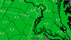
With four to six inches of snow possible on Tuesday, the National Weather Service states the heaviest snow will fall from late morning into the afternoon.
Here’s more in a statement from the weather service:
THE NATIONAL WEATHER SERVICE IN BALTIMORE MD/WASHINGTON HAS
ISSUED A WINTER STORM WARNING FOR SNOW…WHICH IS IN EFFECT FROM
7 AM TO 11 PM EST TUESDAY. THE WINTER STORM WATCH IS NO LONGER IN EFFECT.
* PRECIPITATION TYPE…SNOW
* ACCUMULATIONS…4 TO 6 INCHES.
* TIMING…TUESDAY THROUGH TUESDAY EVENING. THE HEAVIEST SNOW
WILL BE LATE TUESDAY MORNING THROUGH TUESDAY AFTERNOON.
* TEMPERATURES…DROPPING INTO THE TEENS. WIND CHILL VALUES WILL BE IN THE SINGLE DIGITS ZERO TUESDAY AFTERNOON DROPPING TO MINUS 10 TUESDAY NIGHT.
* WINDS…BECOMING NORTH 10 TO 15 MPH WITH GUSTS AROUND 25 MPH TUESDAY AFTERNOON AND EVENING.
* IMPACTS…ROADS WILL BE SNOW COVERED AND SLIPPERY. THE COMBINATION OF SNOW AND BLOWING SNOW WILL REDUCE VISIBILITY TO BELOW ONE-HALF MILE AT TIMES. TRAVELING MAY BE DANGEROUS TUESDAY. THE MORNING AND EVENING COMMUTE MAY BE IMPACTED BY THE SNOW.
9:05 a.m.
A winter storm watch will go into effect at 7 a.m. Tuesday lasting until 11 p.m. as the region could be blanketed with as many as four inches of snow.
Here’s the National Weather Service bulletin:
THE NATIONAL WEATHER SERVICE IN BALTIMORE MD/WASHINGTON HAS ISSUED A WINTER STORM WATCH…WHICH IS IN EFFECT FROM TUESDAY MORNING THROUGH TUESDAY EVENING.
* PRECIPITATION TYPE…SNOW
* ACCUMULATIONS…POTENTIAL FOR FIVE INCHES OR MORE.
* TIMING…TUESDAY THROUGH TUESDAY EVENING. THE HEAVIEST SNOW WILL BE LATE TUESDAY MORNING THROUGH TUESDAY AFTERNOON.
* TEMPERATURES…DROPPING INTO THE TEENS.
* WINDS…BECOMING NORTH 10 TO 15 MPH WITH GUSTS AROUND 25 MPH
TUESDAY AFTERNOON AND EVENING.
* IMPACTS…ROADS WILL BE SNOW COVERED AND SLIPPERY. THE
COMBINATION OF SNOW AND BLOWING SNOW WILL REDUCE VISIBILITY TO BELOW ONE-HALF MILE AT TIMES. TRAVELLING MAY BE DANGEROUS TUESDAY. THE MORNING AND EVENING COMMUTE MAY BE IMPACTED BY THE SNOW.
PRECAUTIONARY/PREPAREDNESS ACTIONS…
A WINTER STORM WATCH MEANS THERE IS A POTENTIAL FOR SIGNIFICANT SNOW ACCUMULATIONS THAT MAY IMPACT TRAVEL. CONTINUE TO MONITOR THE LATEST FORECASTS.
Bitter cold temperatures will be a factor in this round of snowfall, and early weather service snowfall estimates indicate that four to six inches of snow could fall in Prince William and Stafford counties, as well as much of the Washington area.
Here’s the latest discussion bulletin about the storm from the weather service:
COLD TEMPERATURES WILL ALSO SUPPORT HIGHER SNOWFALL RATIOS.
THEREFORE…POPS AND SNOWFALL AMOUNTS HAVE BEEN INCREASED AND ACCUMULATING SNOW IS EXPECTED ACROSS THE ENTIRE CWA. A WINTER STORM WATCH IS IN EFFECT FOR THE ENTIRE CWA TUESDAY INTO TUESDAY EVENING. SNOWFALL AMOUNTS NEAR WARNING THRESHOLDS ARE POSSIBLE.
SNOW WILL TAPER OFF TUESDAY EVENING AS THE LOW MOVES AWAY FROM THE AREA. ARCTIC HIGH PRESSURE WILL BUILD TOWARD THE AREA FROM THE NORTH…BUT THE PRESSURE GRADIENT WILL REMAIN STRONG AS THE LOW INTENSIFIES WELL OFF TO OUR NORTHEAST.
WINDY CONDITIONS ARE EXPECTED AND IT WILL BE BITTERLY COLD AS ARCTIC AIR MOVES INTO THE AREA.
MIN TEMPS TUESDAY NIGHT WILL RANGE FROM BELOW ZERO IN THE MOUNTAINS TO THE SINGLE DIGITS ACROSS MOST OTHER LOCATIONS. THE COMBINATION OF GUSTY WINDS AND COLD TEMPS WILL CAUSE DANGEROUSLY LOW WIND CHILLS. WIND CHILL HEADLINES WILL LIKELY BE NEEDED TUESDAY NIGHT.