Update 1:30 p.m.
Follow @PotomacLocal snow updates on Twitter #potostorm
A winter storm warning will go into effect for Prince William and Stafford counties, and Manassas and Manassas Park, as well as the Greater Washington Area at 7 a.m. Tuesday and last through 11 p.m.
With four to six inches of snow possible on Tuesday, the National Weather Service states the heaviest snow will fall from late morning into the afternoon.
Here’s more in a statement from the weather service:
THE NATIONAL WEATHER SERVICE IN BALTIMORE MD/WASHINGTON HAS
ISSUED A WINTER STORM WARNING FOR SNOW…WHICH IS IN EFFECT FROM
7 AM TO 11 PM EST TUESDAY. THE WINTER STORM WATCH IS NO LONGER IN EFFECT.
* PRECIPITATION TYPE…SNOW
* ACCUMULATIONS…4 TO 6 INCHES.
* TIMING…TUESDAY THROUGH TUESDAY EVENING. THE HEAVIEST SNOW
WILL BE LATE TUESDAY MORNING THROUGH TUESDAY AFTERNOON.
* TEMPERATURES…DROPPING INTO THE TEENS. WIND CHILL VALUES WILL BE IN THE SINGLE DIGITS ZERO TUESDAY AFTERNOON DROPPING TO MINUS 10 TUESDAY NIGHT.
* WINDS…BECOMING NORTH 10 TO 15 MPH WITH GUSTS AROUND 25 MPH TUESDAY AFTERNOON AND EVENING.
* IMPACTS…ROADS WILL BE SNOW COVERED AND SLIPPERY. THE COMBINATION OF SNOW AND BLOWING SNOW WILL REDUCE VISIBILITY TO BELOW ONE-HALF MILE AT TIMES. TRAVELING MAY BE DANGEROUS TUESDAY. THE MORNING AND EVENING COMMUTE MAY BE IMPACTED BY THE SNOW.
9:05 a.m.
A winter storm watch will go into effect at 7 a.m. Tuesday lasting until 11 p.m. as the region could be blanketed with as many as four inches of snow.
Here’s the National Weather Service bulletin:
THE NATIONAL WEATHER SERVICE IN BALTIMORE MD/WASHINGTON HAS ISSUED A WINTER STORM WATCH…WHICH IS IN EFFECT FROM TUESDAY MORNING THROUGH TUESDAY EVENING.
* PRECIPITATION TYPE…SNOW
* ACCUMULATIONS…POTENTIAL FOR FIVE INCHES OR MORE.
* TIMING…TUESDAY THROUGH TUESDAY EVENING. THE HEAVIEST SNOW WILL BE LATE TUESDAY MORNING THROUGH TUESDAY AFTERNOON.
* TEMPERATURES…DROPPING INTO THE TEENS.
* WINDS…BECOMING NORTH 10 TO 15 MPH WITH GUSTS AROUND 25 MPH
TUESDAY AFTERNOON AND EVENING.
* IMPACTS…ROADS WILL BE SNOW COVERED AND SLIPPERY. THE
COMBINATION OF SNOW AND BLOWING SNOW WILL REDUCE VISIBILITY TO BELOW ONE-HALF MILE AT TIMES. TRAVELLING MAY BE DANGEROUS TUESDAY. THE MORNING AND EVENING COMMUTE MAY BE IMPACTED BY THE SNOW.
PRECAUTIONARY/PREPAREDNESS ACTIONS…
A WINTER STORM WATCH MEANS THERE IS A POTENTIAL FOR SIGNIFICANT SNOW ACCUMULATIONS THAT MAY IMPACT TRAVEL. CONTINUE TO MONITOR THE LATEST FORECASTS.
Bitter cold temperatures will be a factor in this round of snowfall, and early weather service snowfall estimates indicate that four to six inches of snow could fall in Prince William and Stafford counties, as well as much of the Washington area.
Here’s the latest discussion bulletin about the storm from the weather service:
COLD TEMPERATURES WILL ALSO SUPPORT HIGHER SNOWFALL RATIOS.
THEREFORE…POPS AND SNOWFALL AMOUNTS HAVE BEEN INCREASED AND ACCUMULATING SNOW IS EXPECTED ACROSS THE ENTIRE CWA. A WINTER STORM WATCH IS IN EFFECT FOR THE ENTIRE CWA TUESDAY INTO TUESDAY EVENING. SNOWFALL AMOUNTS NEAR WARNING THRESHOLDS ARE POSSIBLE.
SNOW WILL TAPER OFF TUESDAY EVENING AS THE LOW MOVES AWAY FROM THE AREA. ARCTIC HIGH PRESSURE WILL BUILD TOWARD THE AREA FROM THE NORTH…BUT THE PRESSURE GRADIENT WILL REMAIN STRONG AS THE LOW INTENSIFIES WELL OFF TO OUR NORTHEAST.
WINDY CONDITIONS ARE EXPECTED AND IT WILL BE BITTERLY COLD AS ARCTIC AIR MOVES INTO THE AREA.
MIN TEMPS TUESDAY NIGHT WILL RANGE FROM BELOW ZERO IN THE MOUNTAINS TO THE SINGLE DIGITS ACROSS MOST OTHER LOCATIONS. THE COMBINATION OF GUSTY WINDS AND COLD TEMPS WILL CAUSE DANGEROUSLY LOW WIND CHILLS. WIND CHILL HEADLINES WILL LIKELY BE NEEDED TUESDAY NIGHT.
Recent Stories
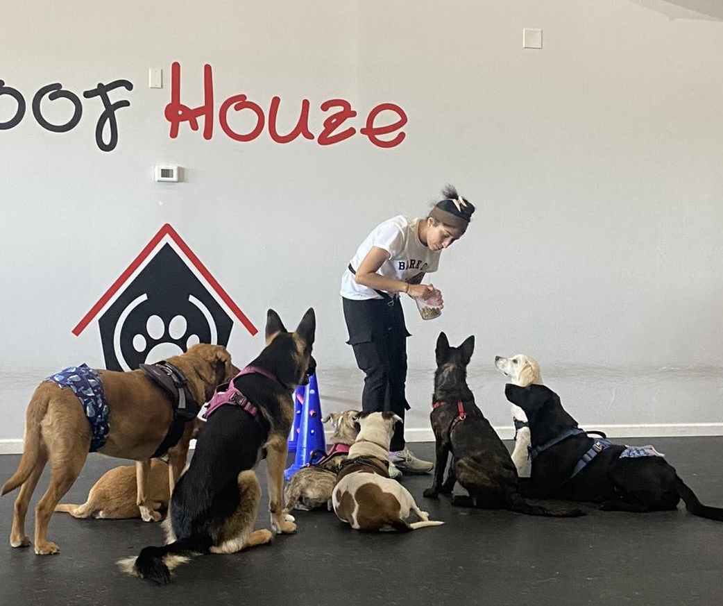
Woof Houze, a dog training and daycare facility in Stafford County, has closed its doors following concerns over silica dust exposure from a neighboring granite and stone business. The business owner, employees, and customers have raised alarms about health hazards, prompting the county to investigate.

Properly using a car seat can reduce the risk of injury or death in a car crash by a significant amount, with studies showing reductions of 71% for infants and 54% for toddlers.
This daily police blotter covers major incidents and arrests, including a sexual assault investigation in Woodbridge, a robbery of a juvenile, felony child neglect in Gainesville, and multiple drug-related offenses at Rappahannock Regional Jail.

Manassas is working on a major maintenance project at Harris Pavilion, a well-known community hub in the heart of downtown.

Properly using a car seat can reduce the risk of injury or death in a car crash by a significant amount, with studies showing reductions of 71% for infants and 54% for toddlers.
Check your child safety seat with the Montgomery County Safe Kids Coalition on Thursday March 20, 2025 from 10am-12:30pm. No appointment necessary.
Fitzgerald GMC Rockville

McClung-Logan Equipment Company is hosting its 40th Annual Oyster Roast, a signature customer appreciation event celebrating tradition, community, and generosity.
This year’s milestone celebration will take place on Thursday, March 6th, from 4:00 PM to 7:00 PM at the Fredericksburg Agricultural Fairgrounds.
The first Oyster Roast began as a fundraiser in 1985, led by White Oak Equipment founder Frank McCarty, to raise donations for an employee battling cancer. This turned into a time-honored tradition for individuals facing hardship.
Environmental Film Festival: Turtle Walker

DC Premiere.
In the late 1970s, Satish Bhaskar embarked on an epic journey along India’s coastline and the spectacular Andaman and Nicobar Islands, where he uncovered the vital nesting beaches of sea turtles. During his death-defying quest, he unravels mysteries