 Today’s weather forecast is sponsored by Water’s End Brewery. Sometimes all you need is a Damn Beer. Take 96oz of this crisp, Golden Ale brewed fresh by Water’s End Brewery to-go with you in a 6-Pounder for just $14.99!
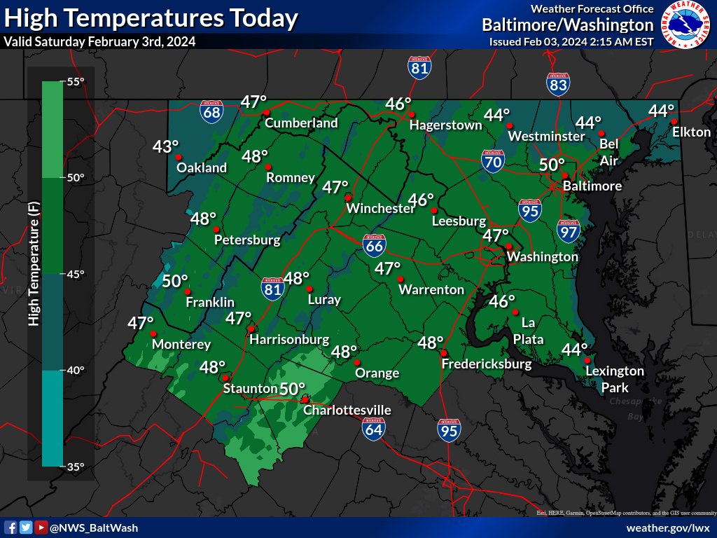
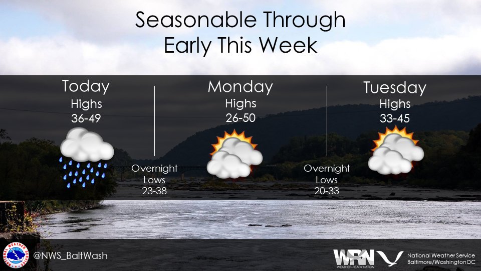
The National Weather Service forecast for the Mid-Atlantic region indicates that high pressure will dominate the weather through the middle of next week.
Clear skies are expected as dry air moves in with northerly winds. Today will be sunny with a high near 47 and a north wind around 8 mph. Tonight will be clear with a low around 27 and a north wind of 3 to 5 mph.
Sunday is expected to be sunny with a high near 50 and a north wind of around 5 mph, becoming calm in the afternoon. Sunday night will be clear with a low around 27 and a calm wind becoming north around 5 mph after midnight.
Monday will be sunny with a high near 48 and a north wind around 7 mph.
Overall, the weather will be seasonable, with temperatures slightly above average during the day and near normal at night.
Today’s weather forecast is sponsored by Water’s End Brewery. Sometimes all you need is a Damn Beer. Take 96oz of this crisp, Golden Ale brewed fresh by Water’s End Brewery to-go with you in a 6-Pounder for just $14.99!
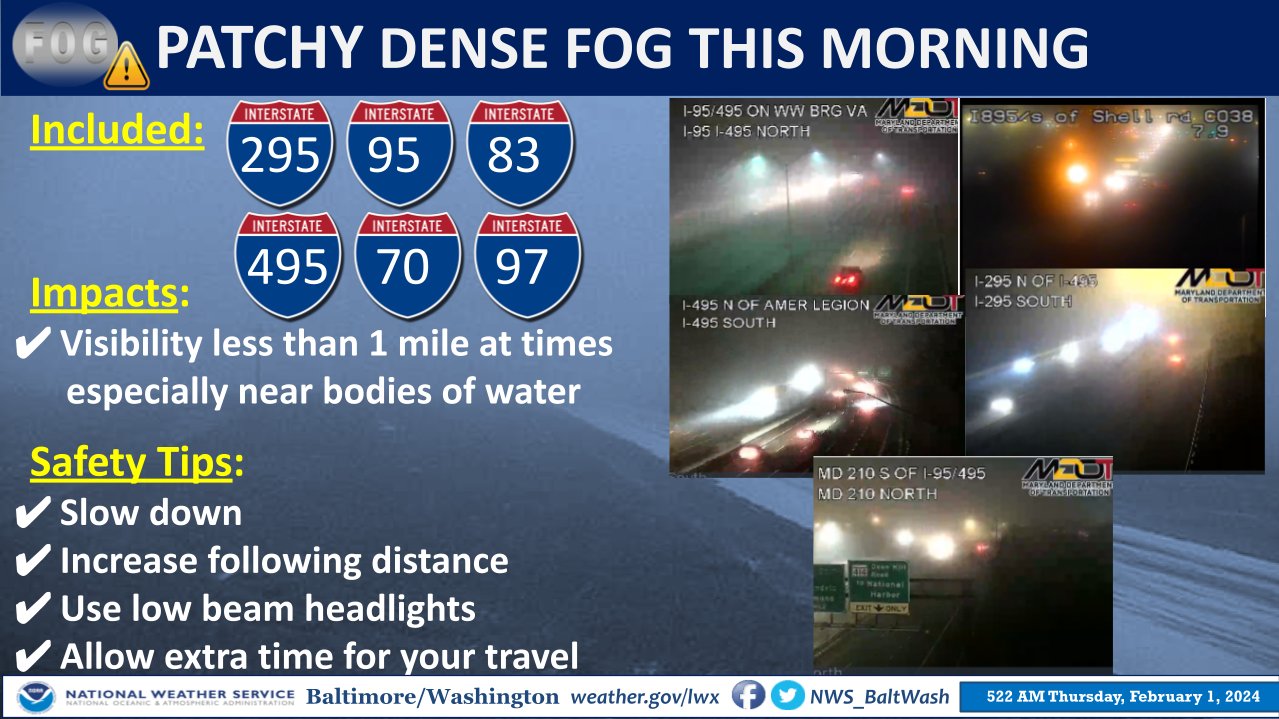
The National Weather Service Baltimore-Washington states high pressure is building across the southeast U.S., with a cold front approaching from the Northeast and Great Lakes. This front will move south on Friday, and high pressure is expected to dominate the Mid-Atlantic weather through early next week. Patchy, dense river fog may cause visibility issues for motorists near larger waterways until just after daybreak, and areas near or below freezing could experience patchy slick spots, especially on elevated and untreated surfaces.
Today’s weather includes patchy fog before 7 a.m., becoming sunny with a high near 53. Southwest winds will bring mild temperatures. There’s a chance of isolated showers after 4 a.m., with mostly cloudy conditions and a low of around 39.
On Friday, isolated showers are possible before 10 a.m. and after 1 p.m. It will be mostly cloudy with a high near 51. Friday night will be mostly clear with a low around 30 and a north wind of 7 to 9 mph.
The weekend forecast includes sunny Saturday weather with a high near 47 and mostly clear skies at night with a low around 27. Sunday will be sunny, with a high near 54.
Today’s weather forecast is sponsored by Water’s End Brewery. Sometimes all you need is a Damn Beer. Take 96oz of this crisp, Golden Ale brewed fresh by Water’s End Brewery to-go with you in a 6-Pounder for just $14.99!
Summary of the weather forecast from the National Weather Service:
- An upper-level low and associated surface low pressure/cold front are crossing the central and southern Appalachians.
- A cloud shield associated with the low is causing a few sprinkles or flurries in the Mid-Atlantic region.
- Measurable precipitation and accumulating snowfall are limited, with a drying trend expected as the low moves offshore.
- Lingering moisture may result in a few sprinkles or flurries into the early afternoon, especially along/west of the Allegheny Front.
- Temperatures will be near to slightly above normal, with highs in the 40s (30s over mountains) and lows in the 30s (20s in sheltered valleys and over higher terrain).
- Some patchy fog is possible in areas where low-level moisture lingers and clouds break.
Extended Forecast:
- Wednesday: Scattered sprinkles before 1 pm, mostly cloudy, with a high near 47. Calm wind becoming northeast around 5 mph in the morning.
- Wednesday Night: Mostly cloudy, with a low around 32. Light and variable wind.
- Thursday: Mostly sunny, with a high near 54. Southwest wind 3 to 7 mph.
- Thursday Night: Mostly cloudy, with a low around 38. Calm wind becoming northwest around 5 mph after midnight.
- Friday: Partly sunny, with a high near 52.
Today’s weather forecast is sponsored by Water’s End Brewery. Sometimes all you need is a Damn Beer. Take 96oz of this crisp, Golden Ale brewed fresh by Water’s End Brewery to-go with you in a 6-Pounder for just $14.99!
The weather forecast from the National Weather Service indicates that an upper-level trough is moving offshore, with another one expected by Tuesday night. Blustery northwest winds today will lead to wind chills in the 20s and 30s, along with broken cloud cover. Winds will diminish tonight, allowing temperatures to drop into the 20s to around freezing.
Dry weather is expected tonight into Tuesday, but clouds will increase during the day Tuesday as a clipper system approaches from the Great Lakes. The short-term forecast for Tuesday night through Wednesday night suggests a chance a mix of rain and snow, with light accumulations.
As the trough and associated low-pressure move offshore on Wednesday/Wednesday night, precipitation should shift southeastward and weaken. Lower elevations might see a mix with or change to rain on Wednesday, with relatively light amounts. Drying is anticipated Wednesday night, with temperatures falling into the 20s to around freezing, potentially causing freezing on untreated surfaces.
The detailed daily forecast:
- Today: Partly sunny with a high near 47, blustery northwest winds, and gusts up to 30 mph.
- Tonight: Partly cloudy with a low around 30, diminishing north winds, and gusts up to 20 mph.
- Tuesday: Partly sunny with a high near 45, light and variable wind becoming southeast 5 to 7 mph.
- Tuesday Night: A chance of rain and snow after 1 am, mostly cloudy with a low around 34, and a 30% chance of precipitation.
- Wednesday: A chance of rain and snow before 10 am, then a chance of rain between 10 am and 1 pm. Cloudy with a high near 44 and a 30% chance of precipitation. Light and variable wind becoming northeast around 6 mph in the morning.
Today’s weather forecast is sponsored by Water’s End Brewery. Sometimes all you need is a Damn Beer. Take 96oz of this crisp, Golden Ale brewed fresh by Water’s End Brewery to-go with you in a 6-Pounder for just $14.99!
The National Weather Service forecasts a brief period of gusty east to northeast winds this morning into early afternoon along/east of I-95, with gusts up to 20-25 mph. Temperatures today will remain in the 40s, reaching 50 degrees in some spots in central Virginia and far southern Maryland.
Dry conditions return after sunrise on Monday, with gusty northwest winds developing, peaking at 25-35 mph. Monday’s highs are expected to be in the mid to upper 40s, dropping to the 20s Monday night.
Rain is likely today (Sunday, January 28, 2024) and tonight, with a chance of precipitation around 90% today and 60% tonight.
Monday will be partly sunny and breezy, with a high near 47, and Monday night will be partly cloudy, with a low around 29.
Tuesday is forecasted to be mostly sunny, with a high near 45 and light and variable winds.
Today’s weather forecast is sponsored by Water’s End Brewery. Sometimes all you need is a Damn Beer. Take 96oz of this crisp, Golden Ale brewed fresh by Water’s End Brewery to-go with you in a 6-Pounder for just $14.99!

Flood Watch Issued
“A Flood Watch has been issued for a large portion of our region along and east of the Blue Ridge Mountains from Nelson Co up to southern Baltimore Co. This Flood Watch is in effect for late this evening into Sun morning. Total amounts will range from 1.50-2.00″. The National Weather Service forecast indicates that a low-pressure system will move from the lower Mississippi River Valley to the Mid-Atlantic through Sunday morning, eventually moving offshore Sunday evening,” reports the National Weather Service.
Detailed forecast
In the near term, dry conditions are expected through early Saturday afternoon before rain moves in. There’s a short window for temperatures to reach the upper 50s to possibly low 60s early this afternoon before rain begins. Rainfall amounts of 1.25 inches to 1.50 inches are expected, with isolated higher amounts around two inches, particularly tonight. While widespread flooding is not anticipated, urban, low-lying, and flood-prone areas could experience minor flooding.
On Sunday, as the low pressure passes overhead, rain becomes more showery in nature, especially south of I-66/US-48. Rain chances remain high, with periods of drizzle or dry conditions. The forecast becomes more uncertain on Sunday afternoon into Sunday night as the low pushes offshore.
Winds veer northwest/north bringing in a colder air mass, and there is a chance of snow in the mountains and parts of north-central and northeast Maryland on Sunday night. Snow amounts of 1-2 inches are possible in parts of the Alleghenies, with some light freezing rain in elevated valleys out west.
Conditions dry out on Monday morning as a cold front sweeps through the area, with gusty NW winds developing later in the day. Highs on Monday will be near normal, reaching the 40s to possibly around 50F in central Virginia, with seasonal cold air returning Monday night and dropping lows to the 20s areawide.
Today’s weather forecast is sponsored by Water’s End Brewery. Sometimes all you need is a Damn Beer. Take 96oz of this crisp, Golden Ale brewed fresh by Water’s End Brewery to-go with you in a 6-Pounder for just $14.99!
The National Weather Service forecasts a weakening cold front crossing the region today, followed by another wave of low pressure in the Mid-Atlantic over the weekend. High pressure is expected to return early next week.
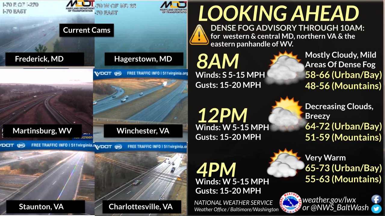
Today and Saturday will see well above normal temperatures, cooling conditions are anticipated on Sunday into the next week. An area of low pressure over the Ohio River valley will move northeast, bringing a warm front overhead and a subsequent cold front that will stall to the south in the evening.
Dense Fog Advisories are in effect, but they will lighten up by late morning, with mainly dry conditions in the afternoon.Temperatures will be well above normal, reaching highs in the upper 60s to low 70s, and overnight lows will cool to the 40s across the area.
Today
Partly sunny, with a high near 73. Southwest wind 7 to 9 mph, with gusts as high as 20 mph.
Tonight
Mostly cloudy, with a low of around 45. North wind 5 to 7 mph.
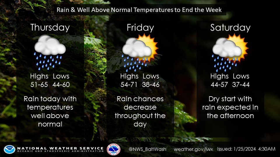
Saturday
Rain, mainly after 4pm. High near 58. North wind 3 to 6 mph. Chance of precipitation is 80%. New precipitation amounts of less than a tenth of an inch possible.
Saturday Night
Rain. Low around 42. East wind around 7 mph. The chance of precipitation is 100%. New precipitation amounts between a half and three-quarters of an inch possible.
Sunday
Rain. High near 48. North wind 7 to 10 mph. The chance of precipitation is 90%.
Today’s weather forecast is sponsored by Water’s End Brewery. Sometimes all you need is a Damn Beer. Take 96oz of this crisp, Golden Ale brewed fresh by Water’s End Brewery to-go with you in a 6-Pounder for just $14.99!
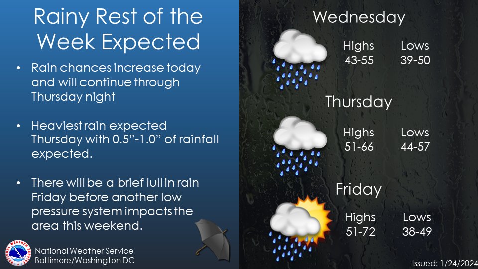
The National Weather Service forecast indicates that low pressure is moving from the Lower Mississippi Valley toward the Great Lakes through tonight. A weakening cold front associated with this system is expected to cross the region on Friday. Another wave of low pressure will approach from the Mid-South late Saturday into Sunday, with high pressure returning early next week.
In the near term (through tonight), rain is expected, especially in northern and western parts of the area. A warm front bisects southern Maryland to Stafford/Orange Counties, leading to temperature differences. Fog development is limited, and a Dense Fog Advisory in northeast Maryland may be canceled with the incoming rain. Showers will continue through mid-morning, with a relative break during midday. Rain coverage will increase again in the late afternoon and evening.
Rain totals are forecasted to be modest, generally in the range of 0.25-0.75 inches for most areas, with locally higher amounts west of the Allegheny Front. A Flood Watch is in effect due to the rapid melt of the deep snowpack. After the steadier rain ends, fog may develop overnight.
Temperatures are expected to be tricky due to the warm front, with highs in the 50s north and west of Washington, D.C. Some places may stay in the 40s, especially near the Pennsylvania border. The front may wiggle back south tonight.
Today’s forecast includes showers with patchy fog before 3 pm, followed by areas of fog after 5 p.m. The high is expected to be near 65. Tonight, showers and possibly a thunderstorm are forecasted before 10 p.m., with scattered showers and thunderstorms between 10 pm and 1 am, and scattered showers after 1 am. The low is around 57. Friday brings scattered showers mainly before 10 am, with areas of fog before 11 a.m. Otherwise, it will be mostly cloudy with a high near 69. Friday night has a slight chance of showers before 1 am, with mostly cloudy conditions and a low around 45.
Today’s weather forecast is sponsored by Water’s End Brewery. Sometimes all you need is a Damn Beer. Take 96oz of this crisp, Golden Ale brewed fresh by Water’s End Brewery to-go with you in a 6-Pounder for just $14.99!
The National Weather Service forecast indicates that a few waves of low pressure will move from the lower Mississippi River Valley to the Great Lakes through late week, bringing a cold front across the Mid-Atlantic by Friday. Another area of low pressure is expected to move from the Mid-South to the Mid-Atlantic over the weekend.
So far, radar returns have been limited in the covered area, and the atmosphere is not yet saturated. The risk of freezing rain or freezing drizzle appears to be very low. Precipitation is expected to remain limited throughout the day, with rain likely increasing later in the afternoon as a shortwave trough and deeper moisture approach. The temperature range is anticipated to be between the mid-40s and mid-50s.
Rain chances are expected to increase tonight as the axis of vorticity advection and deeper moisture spreads eastward across the area. However, the precipitation amounts are forecasted to be light for most areas. Temperatures may not fall significantly from daytime highs and could increase overnight as southerly winds pick up. The higher winds are likely to bring higher dew points, increasing the likelihood of fog.
– Today:
– Chance of sprinkles with a slight chance of rain before 11 am.
– Chance of rain, mainly between 11 am and 4 pm.
– Mostly cloudy with a high near 48.
– Calm wind becoming south around 6 mph.
– Chance of precipitation is 30%.
– Tonight:
– Rain likely, mainly after 4 am.
– Patchy fog after 8 pm.
– Cloudy, with a temperature rising to around 55 by 4 am.
– South wind 3 to 8 mph.
– Chance of precipitation is 60%.
– New precipitation amounts of less than a tenth of an inch possible.
– Thursday:
– Rain with patchy fog before 5 pm.
– High near 63.
– South wind 7 to 10 mph.
– Chance of precipitation is 80%.
– New precipitation amounts of less than a tenth of an inch possible.
– Thursday Night:
– Rain likely, mainly after 1 am.
– Patchy fog after 7 pm.
– Cloudy, with a low around 57.
– Southwest wind around 9 mph.
– Chance of precipitation is 60%.
– New precipitation amounts of less than a tenth of an inch possible.