 Prince William Parks and Recreation sponsors today’s weather forecast.
Summer Job Alert: Parks and Recreation Hiring Seasonal Workers Now! Want to earn some extra cash this summer and enjoy your job at the same time? PWC Parks and Recreation is now hiring for seasonal jobs.. Camp Counselors, Lifeguards, Cooks and more…
As residents are in unseasonably warm temperatures, the National Weather Service is alerted to an impending shift in weather patterns. Currently, in command, high pressure is poised to yield to a low-pressure system approaching from the Ohio Valley.
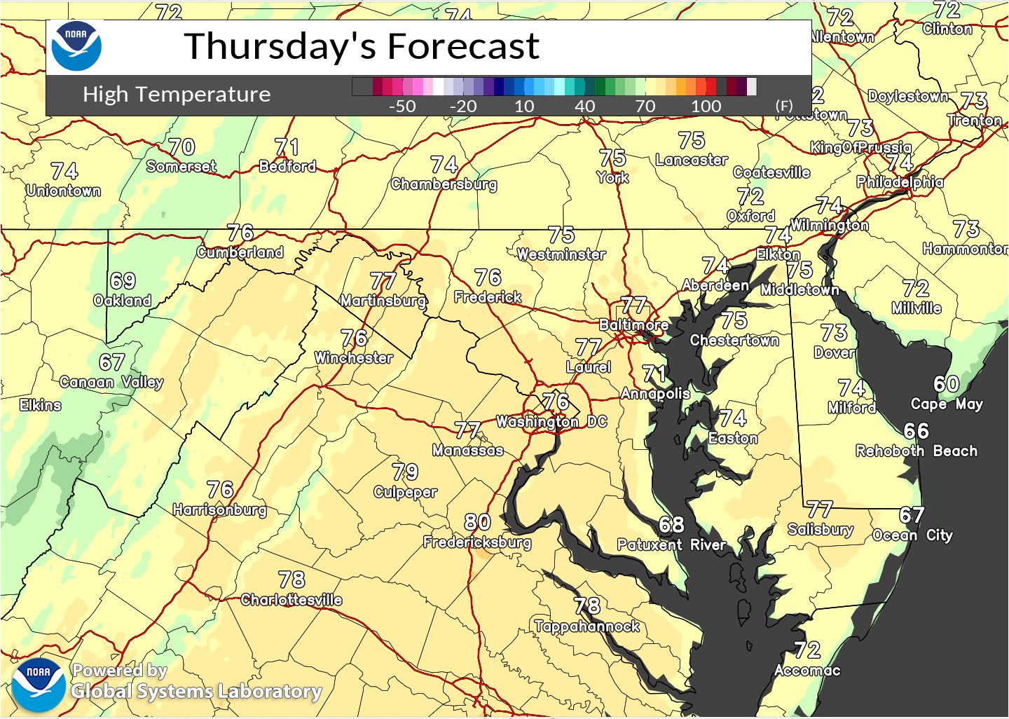
Today’s forecast promises continued dry conditions and temperatures well above the norm. Despite a mix of sun and clouds, highs are expected to reach the mid-70s to near 80. This warmth, however, will be short-lived as a change looms on the horizon.
Tonight, as the center of low pressure nears the Great Lakes, a warm front extending across portions of Pennsylvania heralds the onset of change. Overnight lows are forecasted to be well above average, with widespread 50s anticipated. While most of the region will remain dry, areas along the Alleghenies and the MD/PA border may experience light rain late into the night, primarily after midnight.
Looking ahead to Friday, the transition becomes more apparent. Rain, accompanied by a few thunderstorms, is expected to encroach upon the area, with the likelihood increasing as the day progresses. Cloud cover will intensify, keeping temperatures around the 77-degree mark. The evening brings continued chances of rain and thunderstorms, tapering off towards the late hours but leaving behind mostly cloudy skies and cooler temperatures in the high 40s.
This pattern sets the stage for a potentially unsettled weekend, with a weaker secondary system projected to affect the region from Sunday into Monday. Following the passage of these weather systems, a cooler air mass is anticipated to dominate much of the upcoming week, starkly contrasting the unseasonable warmth experienced in recent days.
Prince William Parks and Recreation sponsors today’s weather forecast.
Summer Job Alert: Parks and Recreation Hiring Seasonal Workers Now! Want to earn some extra cash this summer and enjoy your job at the same time? PWC Parks and Recreation is now hiring for seasonal jobs.. Camp Counselors, Lifeguards, Cooks and more…
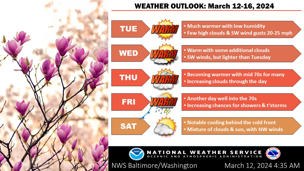
Residents of the Mid-Atlantic can expect a continuation of pleasant weather conditions through mid-week, with high pressure dominating the region. According to the latest forecast from the National Weather Service, temperatures are on a steady climb, reaching well above normal by the end of the work week.
Today, skies are expected to remain mostly sunny, courtesy of a high-pressure system centered to the south. However, gusty winds out of the west, ranging from 20 to 30 mph, are likely across the northern half of the area and higher elevations. Despite this, temperatures are set to rise, with highs near 70 degrees Fahrenheit.
Overnight, conditions will remain mostly clear with temperatures dropping to the upper 30s in higher terrain and mid-40s near the waters. Winds are expected to ease to around 3 to 5 mph.
Wednesday will see a continuation of mostly sunny conditions with temperatures hovering around 71 degrees Fahrenheit. Winds will remain light from the southwest.
By Thursday, the region will experience even warmer temperatures, with highs reaching 76 degrees Fahrenheit. Winds will remain calm in the morning but are expected to pick up to around 5 to 8 mph from the southwest in the afternoon.
Looking ahead, a low-pressure system is set to approach the Mid-Atlantic by Friday, bringing with it increased chances for rain showers. Additionally, another system is forecasted to approach early next week, potentially impacting the region’s weather patterns.
Residents and travelers in the area are advised to stay updated on the latest weather forecasts and plan accordingly for any outdoor activities, especially towards the end of the week when rain showers become more likely.
Prince William Parks and Recreation sponsors today’s weather forecast.
Summer Job Alert: Parks and Recreation Hiring Seasonal Workers Now! Want to earn some extra cash this summer and enjoy your job at the same time? PWC Parks and Recreation is now hiring for seasonal jobs.. Camp Counselors, Lifeguards, Cooks and more…

Residents can expect continued windy conditions this afternoon as the National Weather Service forecasts strong winds until late afternoon.
High pressure is anticipated to return tonight and persist through the middle of the week, bringing with it rapidly rising temperatures well above the seasonal average. However, there is a potential for another bout of unsettled weather toward the week’s end.
The latest observations reveal winds of up to 40 knots at approximately 2,800 feet above ground level, indicating the possibility of gusts exceeding 45 mph as boundary layer mixing intensifies. Despite the persisting gusts, forecast soundings suggest a gradual decrease in maximum gust potential throughout the afternoon, raising the possibility of an early cancellation of the Wind Advisory.
Throughout the afternoon, any lingering clouds along the Allegheny Front are expected to dissipate, giving way to abundant sunshine. Temperatures are forecasted to reach the 50s across most areas, with slightly cooler conditions in the mountains where highs are expected to remain in the 40s.
As evening approaches, winds are expected to diminish as the pressure gradient over the region weakens. Nonetheless, gusty winds, reaching speeds of around 20-25 mph, are forecasted to persist through the night, particularly on elevated terrain where a low-level jet stream may enhance wind speeds. Overnight temperatures are expected to settle in the 30s, around normal for this time of year.
Looking ahead, Tuesday promises sunny skies with highs soaring to around 70°F, accompanied by a gentle west wind. Overnight, temperatures are forecasted to remain mild, with mostly clear conditions and lows hovering around 40°F. Wednesday follows suit with mostly sunny skies and highs in the low 70s, while Wednesday night is expected to be mostly clear with lows around 45°F.
In the short term, a large surface high centered over the Southeastern United States is set to move offshore into the southwestern Atlantic, maintaining dry conditions through midweek.
With temperatures well above average, reaching the 60s to lower 70s during the day and upper 30s to 40s at night, residents can anticipate a welcome respite from the recent cold snap.
Prince William Parks and Recreation sponsors today’s weather forecast.
Summer Job Alert: Parks and Recreation Hiring Seasonal Workers Now! Want to earn some extra cash this summer and enjoy your job at the same time? PWC Parks and Recreation is now hiring for seasonal jobs.. Camp Counselors, Lifeguards, Cooks and more…
 Residents of the Mid-Atlantic states can expect some changes in the weather over the next few days, according to the latest forecast from the National Weather Service. High pressure will remain in place today, but an area of low pressure is set to move across the region on Saturday, bringing with it unsettled conditions.
Today, partly sunny skies are anticipated, with a high near 61 degrees. However, as high pressure moves off to the east, clouds will increase throughout the day. Due to the cloud cover, temperatures will be cooler compared to yesterday, but they will still remain above average, reaching into the upper 50s to low 60s.
As the day progresses, winds will shift out of the southeast. There’s a chance of rain moving in after 4 a.m. Saturday, with temperatures dropping to around 42 degrees. The rain is expected to continue into Saturday, becoming heavier by morning. Saturday’s forecast calls for rain, mainly after 7 a.m., with a high near 56 degrees. The chance of precipitation is 100%, with new precipitation amounts between a quarter and half of an inch possible.
The unsettled weather is expected to persist into Saturday night, with rain likely before 1 a.m. Sunday. Clouds will gradually decrease, becoming partly cloudy by early Sunday morning. Sunday’s forecast offers a return to mostly sunny skies, with a high near 53 degrees Fahrenheit. However, it will be breezy, with west winds increasing throughout the day.
Heading into the new week, dry, cool, and breezy conditions are expected to return as high pressure builds back into the region late Sunday into the early part of next week. Monday’s forecast calls for sunny skies with a high near 55 degrees Fahrenheit, accompanied by breezy conditions.
Prince William Parks and Recreation sponsors today’s weather forecast.
Summer Job Alert: Parks and Recreation Hiring Seasonal Workers Now! Want to earn some extra cash this summer and enjoy your job at the same time? PWC Parks and Recreation is now hiring for seasonal jobs.. Camp Counselors, Lifeguards, Cooks and more…
Expect a brief reprieve from wet weather as high pressure takes hold over the Mid-Atlantic states today. According to the latest forecast from the National Weather Service, dry, cool, and breezy conditions will prevail until another low-pressure system approaches over the weekend.
As low pressure exits to the northeast, any lingering light rain over northern Maryland is expected to dissipate in the coming hours. Patchy fog may cause locally dense conditions, particularly near and west of the Blue Ridge, but this is anticipated to improve as the morning progresses.
Throughout the day, clouds will gradually decrease east of the Blue Ridge, leading to significant clearing by the afternoon. Temperatures are forecasted to reach the 60s for much of the area, with the potential for highs near 70 in central Virginia Piedmont if clearing occurs earlier than expected.
Tonight, partly cloudy skies are expected with lows dipping into the upper 30s to low 40s. Clouds will begin to build in again late tonight as low pressure approaches heading into Friday.
Tomorrow, partly sunny conditions are forecasted with a high near 60, although clouds will increase ahead of the approaching low-pressure system. Friday night may see a chance of rain after 1 am, with mostly cloudy skies and lows around 42.
The weekend outlook indicates a return to wet weather, with rain expected on Saturday. Highs are forecasted near 58, accompanied by southeast winds and a 90% chance of precipitation.
Residents are advised to stay updated on the evolving weather conditions and prepare accordingly for the rainy weekend ahead.
Prince William Parks and Recreation sponsors today’s weather forecast.
Summer Job Alert: Parks and Recreation Hiring Seasonal Workers Now! Want to earn some extra cash this summer and enjoy your job at the same time? PWC Parks and Recreation is now hiring for seasonal jobs.. Camp Counselors, Lifeguards, Cooks and more…
Residents in the Mid-Atlantic region can expect unsettled weather as a low-pressure system tracks up the East Coast, accompanied by a cold front advancing from the Ohio River Valley. According to the National Weather Service, this system will bring a mix of rain, fog, and drizzle to the area through tonight.
The day started with a blanket of mid and high-level clouds, hindering the visibility of low clouds and fog. However, surface observations indicate the gradual advancement of fog and low clouds, driven by light southeast winds. These conditions are expected to persist through the morning, gradually lifting as rain approaches from the southwest later in the afternoon.
While the most significant dynamics are expected along a coastal front to the east, sufficient lift and moisture advection are forecasted to produce rain locally as a mid-level dry pocket is overcome later in the day. Rain is anticipated to be most prevalent late this afternoon and into the evening as the coastal low approaches. Additionally, a front from the west will contribute to lift, albeit briefly, into early Thursday morning before dissipating.
Overall, the region should prepare for periods of light rain, drizzle, and areas of fog through tonight as these weather systems traverse the area. Rainfall totals are expected to be higher along the Chesapeake Bay but are forecasted to remain below an inch overall.
Here is a breakdown of the weather forecast:
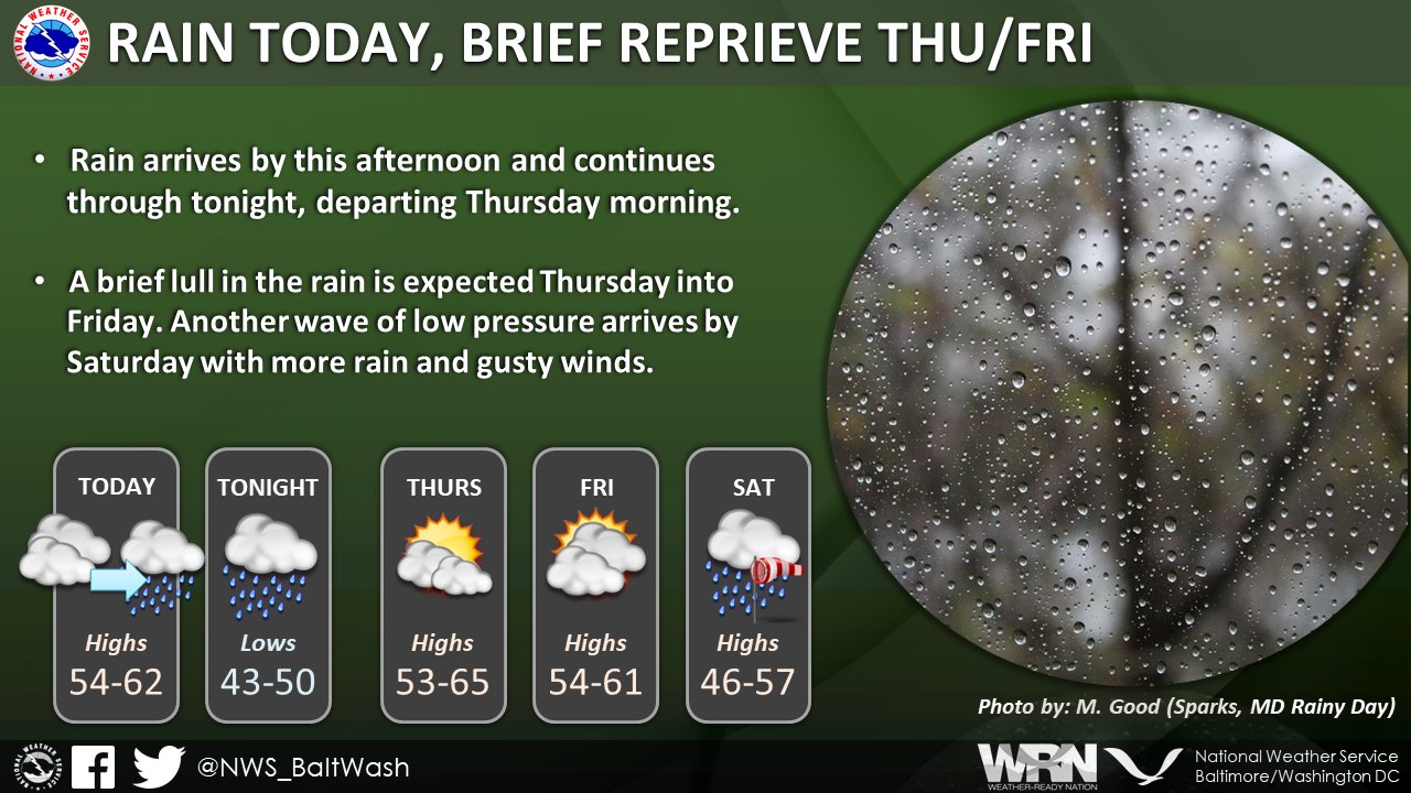
- Today: Rain is expected mainly after 10 am, with areas of fog persisting. The high temperature is forecasted to be near 57 degrees Fahrenheit, with an east wind of around 6 mph. The chance of precipitation is 80%, with new precipitation amounts between a tenth and a quarter of an inch possible.
- Tonight: Rain will continue, primarily before 1 am, with areas of fog persisting until around 3 am. The low temperature is expected to be around 49 degrees Fahrenheit, with a north wind of 6 to 8 mph. The chance of precipitation is 100%, with new precipitation amounts between a tenth and a quarter of an inch possible.
- Thursday: There is a chance of rain, mainly before 10 am, with mostly cloudy skies expected throughout the day. The high temperature will be near 63 degrees Fahrenheit, with a north wind of 8 to 10 mph. The chance of precipitation is 30%.
- Thursday Night: Mostly cloudy conditions are expected, with a low temperature around 42 degrees Fahrenheit and a north wind of around 7 mph.
- Friday: Partly sunny skies are forecasted, with a high temperature near 61 degrees Fahrenheit. The north wind will be around 7 mph, becoming southeast in the afternoon.
- Friday Night: There is a chance of rain after 1 am, with mostly cloudy conditions expected and a low temperature around 42 degrees Fahrenheit. The chance of precipitation is 30%.
- Saturday Rain is likely, with a high temperature near 56 degrees Fahrenheit. The chance of precipitation is 90%.
Prince William Parks and Recreation sponsors today’s weather forecast.
Summer Job Alert: Parks and Recreation Hiring Seasonal Workers Now! Want to earn some extra cash this summer and enjoy your job at the same time? PWC Parks and Recreation is now hiring for seasonal jobs.. Camp Counselors, Lifeguards, Cooks and more…

Residents of the Mid-Atlantic are advised to brace for a series of weather systems set to sweep through the region, bringing a mix of rain, fog, and fluctuating temperatures over the next few days.
The National Weather Service has outlined a dynamic weather scenario, with a low-pressure system currently situated over east-central Virginia expected to track towards New England by tonight. Simultaneously, another area of low pressure is forecast to develop over the Southeast, moving up along the East Coast ahead of an approaching cold front from the Ohio River Valley. This combination of atmospheric conditions is likely to result in unsettled weather patterns across the region.
As of the latest observations, a swirl of low pressure has been identified over east-central Virginia, with a rain shield extending towards the Blue Ridge/Catoctin Mountains. Although the steady rain associated with this system is expected to diminish by mid to late morning, lingering clouds are anticipated, particularly over eastern areas, due to trapped moisture and light winds. Some additional rain showers may persist near northeastern Maryland as the system moves away.
Temperature differentials are also expected across the region, with areas southwest of the Potomac River likely to see high temperatures exceeding 70 degrees, while northeastern Maryland may experience temperatures holding in the 50s.
Looking ahead, tonight could see the development of areas of fog, possibly dense in some locations, especially where breaks in the clouds occur. Additionally, precipitation chances are forecast to increase towards daybreak as another weather system approaches from the Southeast and Ohio River Valley.
Tomorrow, the region is expected to experience rain, particularly after 1 p.m., accompanied by patchy fog in the morning hours. Temperatures are forecast to reach around 61 degrees Fahrenheit. Rainfall is expected to continue into Wednesday night before tapering off.
Looking ahead to weekend, rain is in the forecast Saturday and Sunday.
Prince William Parks and Recreation sponsors today’s weather forecast.
Summer Job Alert: Parks and Recreation Hiring Seasonal Workers Now! Want to earn some extra cash this summer and enjoy your job at the same time? PWC Parks and Recreation is now hiring for seasonal jobs.. Camp Counselors, Lifeguards, Cooks and more…

As residents along the East Coast brace for a bout of inclement weather, the National Weather Service predicts a series of low-pressure systems to impact the region throughout the week. The forecast indicates a complex weather pattern evolving, with the potential for rain and fog affecting various areas.
The current scenario delineates the presence of three distinct weather patterns across the area. East of the Blue Ridge Mountains, stratocumulus clouds have formed, accompanied by patches of fog in areas of clearing. Over the Shenandoah Valley and the I-81 corridor, clearing skies have led to the development of dense fog. Meanwhile, west of I-81 toward the Appalachian Mountains, high clouds dominate the sky, with patches of low-level clouds observed.
Throughout the day, as low pressure develops off the coast of the Carolinas, high clouds are expected to expand from the south. Daytime heating, coupled with light onshore flow, will likely sustain or even augment the presence of stratocumulus clouds, resulting in a mostly cloudy day for many regions. As a consequence, temperatures are anticipated to hover on the cooler side of the spectrum.
Moving into tonight, the low-pressure system near the Carolinas will gradually drift northward, bringing rain to the region. Patchy fog is expected to develop after 11 pm, particularly in areas affected by rainfall. Temperatures are forecasted to dip, with lows around 47 degrees. The chance of precipitation is estimated at 80%, with new rainfall amounts projected to range between a quarter and half of an inch.
On Tuesday, we’ll see continued rainfall, with the possibility of patchy fog persisting into the early hours. As the day progresses, skies are expected to gradually clear, transitioning to mostly sunny conditions. However, a slight chance of rain remains in the forecast for Tuesday night, with mostly cloudy skies prevailing.
Prince William Parks and Recreation sponsors today’s weather forecast.
Summer Job Alert: Parks and Recreation Hiring Seasonal Workers Now! Want to earn some extra cash this summer and enjoy your job at the same time? PWC Parks and Recreation is now hiring for seasonal jobs.. Camp Counselors, Lifeguards, Cooks and more…

Another round of weather challenges is in store today as a robust cold front approaches. The front will bring gusty winds and low relative humidity. The National Weather Service has issued several advisories and warnings, urging caution and preparedness.
The primary concern today is the heightened risk of wildfires, particularly in northern and central Virginia, where a Red Flag Warning is effective from 11 a.m. to 8 p.m. An Elevated Fire Danger Statement is also anticipated for eastern West Virginia, extreme northern Virginia, and the Washington D.C. metro area. While not reaching the criteria for a Red Flag Warning, these areas remain under close observation due to the potential for fire spread.
West of Interstate 81, westerly winds are expected to sustain speeds between 20-35 mph, with gusts up to 50 mph, leading to possible isolated tree damage and power outages. The highest gusts are forecasted within the downslope zone east of the Allegheny Front.
A reinforcing cold front and shortwave trough will pass through the area later in the day, bringing limited moisture in mountain upslope snow showers over the Allegheny Front. However, precipitation amounts are expected to be light, with minimal impact apart from a dusting to perhaps an inch of snow across extreme western Maryland and eastern West Virginia.
Despite the windy conditions, temperatures are forecasted to be relatively mild, with highs reaching the upper 50s and low 60s. Tonight, expect mostly clear skies with temperatures dropping to around 32°F, accompanied by north winds at 10-16 mph.
Looking ahead, Thursday will bring calmer conditions with sunny skies and a high near 51 degrees. Thursday night will remain mostly clear, with temperatures around 31 degrees. By Friday, temperatures will rise slightly, with mostly sunny conditions persisting and a high near 56 degrees.